You are here: Home > Network List > CI - Caltech Regional Seismic Network Stations List
> Station MPM Manuel Prospect Mine, California, USA > Earthquake Result Viewer
MPM Manuel Prospect Mine, California, USA - Earthquake Result Viewer
| Earthquake location: |
South Of Panama |
| Earthquake latitude/longitude: |
7.9/-82.8 |
| Earthquake time(UTC): |
2002/07/31 (212) 00:16:44 GMT |
| Earthquake Depth: |
10 km |
| Earthquake Magnitude: |
6.0 MB, 6.4 MS, 6.5 MW, 6.4 MW |
| Earthquake Catalog/Contributor: |
WHDF/NEIC |
|
| Network: |
CI Caltech Regional Seismic Network |
| Station: |
MPM Manuel Prospect Mine, California, USA |
| Lat/Lon: |
36.06 N/117.49 W |
| Elevation: |
185 m |
|
| Distance: |
42.2 deg |
| Az: |
316.685 deg |
| Baz: |
123.004 deg |
| Ray Param: |
0.07328363 |
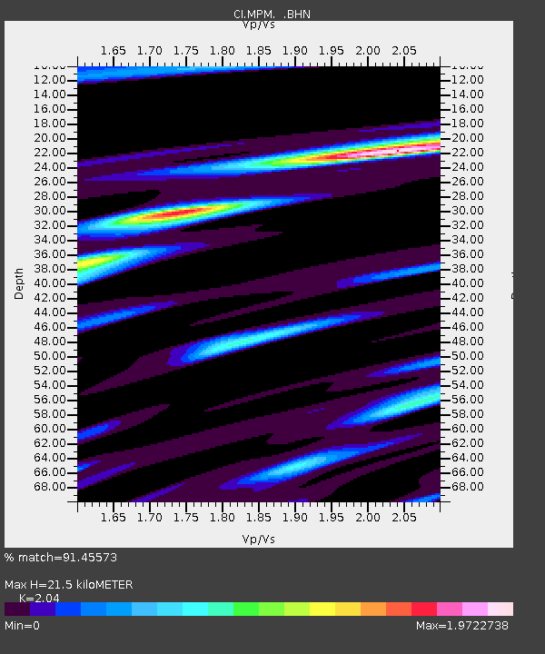
| Estimated Moho Depth: |
21.5 km |
| Estimated Crust Vp/Vs: |
2.04 |
| Assumed Crust Vp: |
6.279 km/s |
| Estimated Crust Vs: |
3.078 km/s |
| Estimated Crust Poisson's Ratio: |
0.34 |
|
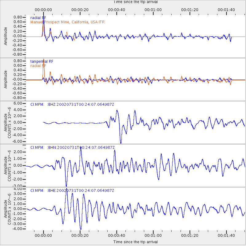
| Radial Match: |
91.45573 % |
| Radial Bump: |
376 |
| Transverse Match: |
81.01033 % |
| Transverse Bump: |
400 |
| SOD ConfigId: |
3770 |
| Insert Time: |
2010-03-05 20:26:28.819 +0000 |
| GWidth: |
2.5 |
| Max Bumps: |
400 |
| Tol: |
0.001 |
|
Signal To Noise
| Channel | StoN | STA | LTA |
| CI:MPM: :BHN:20020731T00:24:07.064987Z | 1.2824043 | 1.1434445E-7 | 8.916412E-8 |
| CI:MPM: :BHE:20020731T00:24:07.064987Z | 1.7956377 | 1.5989545E-7 | 8.904661E-8 |
| CI:MPM: :BHZ:20020731T00:24:07.064987Z | 1.5169091 | 1.7665333E-7 | 1.1645611E-7 |
| Arrivals |
| Ps | 3.8 SECOND |
| PpPs | 9.8 SECOND |
| PsPs/PpSs | 14 SECOND |


