You are here: Home > Network List > TA - USArray Transportable Network (new EarthScope stations) Stations List
> Station R32K Eaglecrest, AK, USA > Earthquake Result Viewer
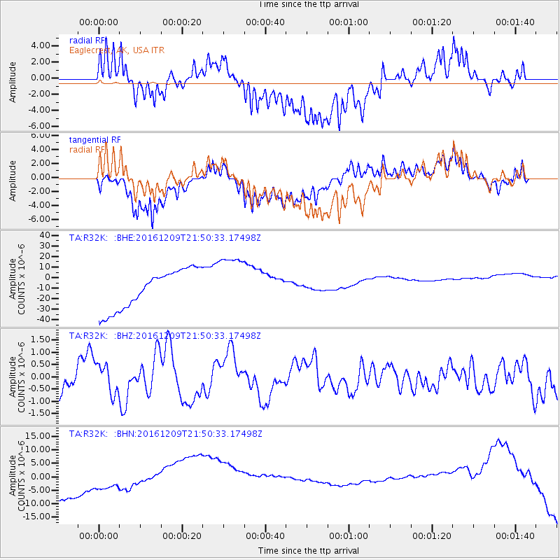
R32K Eaglecrest, AK, USA - Earthquake Result Viewer
*The percent match for this event was below the threshold and hence no stack was calculated.
| Earthquake location: |
Solomon Islands |
| Earthquake latitude/longitude: |
-10.9/161.4 |
| Earthquake time(UTC): |
2016/12/09 (344) 21:38:23 GMT |
| Earthquake Depth: |
10 km |
| Earthquake Magnitude: |
5.8 Mww |
| Earthquake Catalog/Contributor: |
NEIC PDE/us |
|
| Network: |
TA USArray Transportable Network (new EarthScope stations) |
| Station: |
R32K Eaglecrest, AK, USA |
| Lat/Lon: |
58.27 N/134.52 W |
| Elevation: |
386 m |
|
| Distance: |
86.2 deg |
| Az: |
28.442 deg |
| Baz: |
242.278 deg |
| Ray Param: |
$rayparam |
*The percent match for this event was below the threshold and hence was not used in the summary stack. |
|
| Radial Match: |
30.630438 % |
| Radial Bump: |
400 |
| Transverse Match: |
22.51042 % |
| Transverse Bump: |
400 |
| SOD ConfigId: |
11737051 |
| Insert Time: |
2019-04-26 06:57:07.145 +0000 |
| GWidth: |
2.5 |
| Max Bumps: |
400 |
| Tol: |
0.001 |
|
Signal To Noise
| Channel | StoN | STA | LTA |
| TA:R32K: :BHZ:20161209T21:50:33.17498Z | 0.95562035 | 6.123854E-7 | 6.40825E-7 |
| TA:R32K: :BHN:20161209T21:50:33.17498Z | 1.4775864 | 3.0427195E-6 | 2.05925E-6 |
| TA:R32K: :BHE:20161209T21:50:33.17498Z | 1.5002228 | 2.7704466E-5 | 1.84669E-5 |
| Arrivals |
| Ps | |
| PpPs | |
| PsPs/PpSs | |


