You are here: Home > Network List > TA - USArray Transportable Network (new EarthScope stations) Stations List
> Station S22A 4UR Ranch, Creede, CO, USA > Earthquake Result Viewer
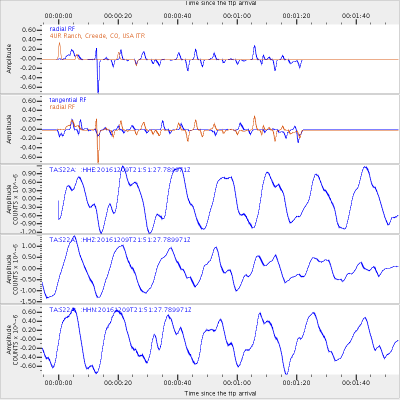
S22A 4UR Ranch, Creede, CO, USA - Earthquake Result Viewer
*The percent match for this event was below the threshold and hence no stack was calculated.
| Earthquake location: |
Solomon Islands |
| Earthquake latitude/longitude: |
-10.9/161.4 |
| Earthquake time(UTC): |
2016/12/09 (344) 21:38:23 GMT |
| Earthquake Depth: |
10 km |
| Earthquake Magnitude: |
5.8 Mww |
| Earthquake Catalog/Contributor: |
NEIC PDE/us |
|
| Network: |
TA USArray Transportable Network (new EarthScope stations) |
| Station: |
S22A 4UR Ranch, Creede, CO, USA |
| Lat/Lon: |
37.75 N/106.83 W |
| Elevation: |
2626 m |
|
| Distance: |
98.0 deg |
| Az: |
53.137 deg |
| Baz: |
262.403 deg |
| Ray Param: |
$rayparam |
*The percent match for this event was below the threshold and hence was not used in the summary stack. |
|
| Radial Match: |
93.767044 % |
| Radial Bump: |
302 |
| Transverse Match: |
90.84436 % |
| Transverse Bump: |
284 |
| SOD ConfigId: |
11737051 |
| Insert Time: |
2019-04-26 06:57:07.459 +0000 |
| GWidth: |
2.5 |
| Max Bumps: |
400 |
| Tol: |
0.001 |
|
Signal To Noise
| Channel | StoN | STA | LTA |
| TA:S22A: :HHZ:20161209T21:51:27.789971Z | 1.2319009 | 7.7397834E-7 | 6.282797E-7 |
| TA:S22A: :HHN:20161209T21:51:27.789971Z | 1.2478377 | 4.2417562E-7 | 3.3992853E-7 |
| TA:S22A: :HHE:20161209T21:51:27.789971Z | 1.4570796 | 8.9914624E-7 | 6.1708795E-7 |
| Arrivals |
| Ps | |
| PpPs | |
| PsPs/PpSs | |


