You are here: Home > Network List > CI - Caltech Regional Seismic Network Stations List
> Station MPM Manuel Prospect Mine, California, USA > Earthquake Result Viewer
MPM Manuel Prospect Mine, California, USA - Earthquake Result Viewer
| Earthquake location: |
Vanuatu Islands |
| Earthquake latitude/longitude: |
-14.4/167.7 |
| Earthquake time(UTC): |
2002/04/11 (101) 21:56:56 GMT |
| Earthquake Depth: |
10 km |
| Earthquake Magnitude: |
5.9 MB, 6.2 MS, 6.2 MW, 6.1 MW |
| Earthquake Catalog/Contributor: |
WHDF/NEIC |
|
| Network: |
CI Caltech Regional Seismic Network |
| Station: |
MPM Manuel Prospect Mine, California, USA |
| Lat/Lon: |
36.06 N/117.49 W |
| Elevation: |
185 m |
|
| Distance: |
86.5 deg |
| Az: |
51.581 deg |
| Baz: |
249.547 deg |
| Ray Param: |
0.043997668 |
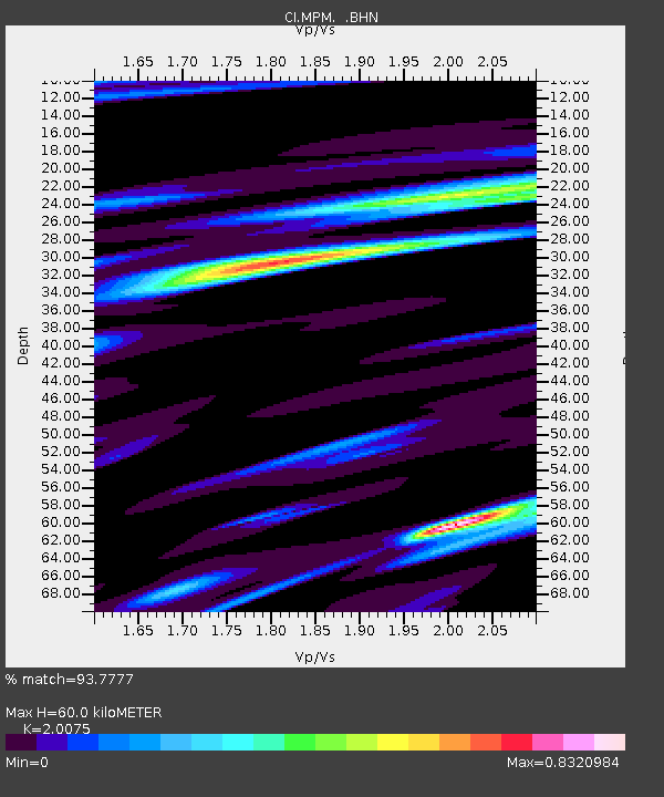
| Estimated Moho Depth: |
60.0 km |
| Estimated Crust Vp/Vs: |
2.01 |
| Assumed Crust Vp: |
6.279 km/s |
| Estimated Crust Vs: |
3.128 km/s |
| Estimated Crust Poisson's Ratio: |
0.33 |
|
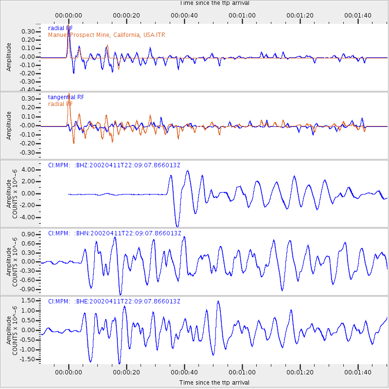
| Radial Match: |
93.7777 % |
| Radial Bump: |
400 |
| Transverse Match: |
89.75448 % |
| Transverse Bump: |
400 |
| SOD ConfigId: |
3787 |
| Insert Time: |
2010-03-05 20:26:58.986 +0000 |
| GWidth: |
2.5 |
| Max Bumps: |
400 |
| Tol: |
0.001 |
|
Signal To Noise
| Channel | StoN | STA | LTA |
| CI:MPM: :BHN:20020411T22:09:07.866013Z | 0.75918394 | 3.7702E-8 | 4.9661217E-8 |
| CI:MPM: :BHE:20020411T22:09:07.866013Z | 1.7836477 | 1.165868E-7 | 6.536425E-8 |
| CI:MPM: :BHZ:20020411T22:09:07.866013Z | 8.202212 | 5.3232753E-7 | 6.4900476E-8 |
| Arrivals |
| Ps | 9.8 SECOND |
| PpPs | 28 SECOND |
| PsPs/PpSs | 38 SECOND |


