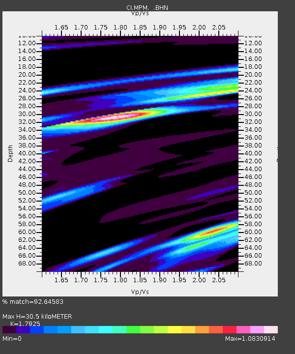
MPM Manuel Prospect Mine, California, USA - Earthquake Result Viewer
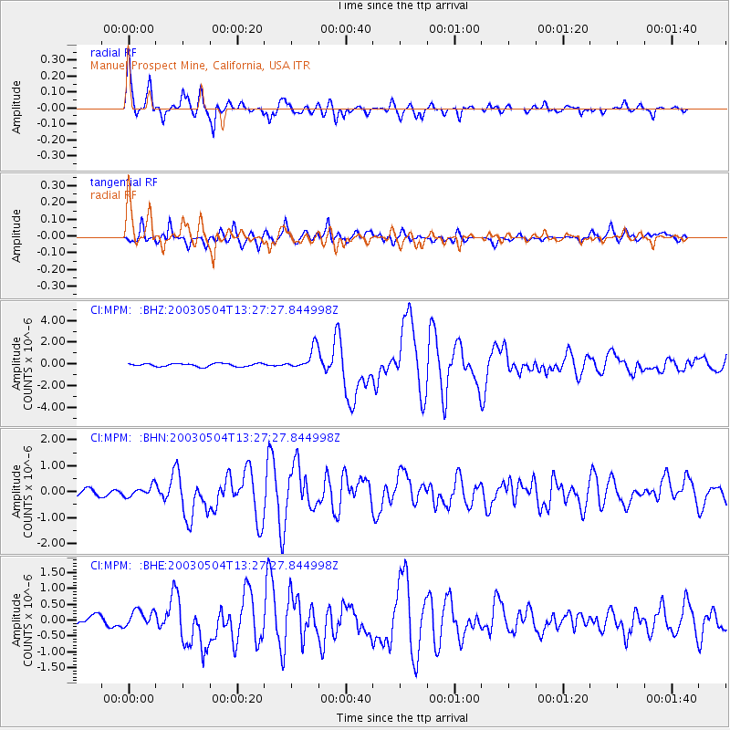
Earthquake location: Kermadec Islands, New Zealand
Earthquake latitude/longitude: -30.5/-178.2
Earthquake time(UTC): 2003/05/04 (124) 13:15:18 GMT
Earthquake Depth: 62 km
Earthquake Magnitude: 6.0 MB, 6.5 MS, 6.7 MW, 6.7 MW
Earthquake Catalog/Contributor: WHDF/NEIC
Network: CI Caltech Regional Seismic Network
Station: MPM Manuel Prospect Mine, California, USA
Lat/Lon: 36.06 N/117.49 W
Elevation: 185 m
Distance: 87.4 deg
Az: 45.045 deg
Baz: 228.899 deg
Ray Param: 0.043247066
Estimated Moho Depth: 30.5 km
Estimated Crust Vp/Vs: 1.79
Assumed Crust Vp: 6.279 km/s
Estimated Crust Vs: 3.503 km/s
Estimated Crust Poisson's Ratio: 0.27
Radial Match: 92.64583 %
Radial Bump: 400
Transverse Match: 87.968445 %
Transverse Bump: 400
SOD ConfigId: 3787
Insert Time: 2010-03-05 20:27:29.804 +0000
GWidth: 2.5
Max Bumps: 400
Tol: 0.001

Signal To Noise

ChannelStoNSTALTA
CI:MPM: :BHN:20030504T13:27:27.844998Z1.44770032.0081931E-71.3871609E-7
CI:MPM: :BHE:20030504T13:27:27.844998Z2.19363622.511827E-71.14505184E-7
CI:MPM: :BHZ:20030504T13:27:27.844998Z7.73446371.0371274E-61.340917E-7
Arrivals
Ps3.9 SECOND
PpPs13 SECOND
PsPs/PpSs17 SECOND