You are here: Home > Network List > CI - Caltech Regional Seismic Network Stations List
> Station MPM Manuel Prospect Mine, California, USA > Earthquake Result Viewer
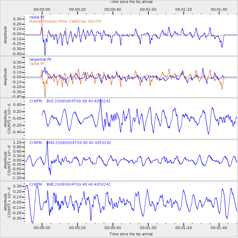
MPM Manuel Prospect Mine, California, USA - Earthquake Result Viewer
*The percent match for this event was below the threshold and hence no stack was calculated.
| Earthquake location: |
Santa Cruz Islands |
| Earthquake latitude/longitude: |
-12.1/167.1 |
| Earthquake time(UTC): |
2008/09/04 (248) 09:37:03 GMT |
| Earthquake Depth: |
272 km |
| Earthquake Magnitude: |
5.5 MB, 5.7 MW, 5.6 MW |
| Earthquake Catalog/Contributor: |
WHDF/NEIC |
|
| Network: |
CI Caltech Regional Seismic Network |
| Station: |
MPM Manuel Prospect Mine, California, USA |
| Lat/Lon: |
36.06 N/117.49 W |
| Elevation: |
185 m |
|
| Distance: |
85.6 deg |
| Az: |
51.861 deg |
| Baz: |
251.66 deg |
| Ray Param: |
$rayparam |
*The percent match for this event was below the threshold and hence was not used in the summary stack. |
|
| Radial Match: |
64.97143 % |
| Radial Bump: |
400 |
| Transverse Match: |
47.946663 % |
| Transverse Bump: |
400 |
| SOD ConfigId: |
2504 |
| Insert Time: |
2010-03-05 20:27:35.416 +0000 |
| GWidth: |
2.5 |
| Max Bumps: |
400 |
| Tol: |
0.001 |
|
Signal To Noise
| Channel | StoN | STA | LTA |
| CI:MPM: :BHN:20080904T09:48:40.495024Z | 3.404734 | 5.1060135E-7 | 1.4996805E-7 |
| CI:MPM: :BHE:20080904T09:48:40.495024Z | 0.5513654 | 1.0401842E-7 | 1.8865606E-7 |
| CI:MPM: :BHZ:20080904T09:48:40.495024Z | 1.5985461 | 2.37369E-7 | 1.4849054E-7 |
| Arrivals |
| Ps | |
| PpPs | |
| PsPs/PpSs | |


