You are here: Home > Network List > CI - Caltech Regional Seismic Network Stations List
> Station MPM Manuel Prospect Mine, California, USA > Earthquake Result Viewer
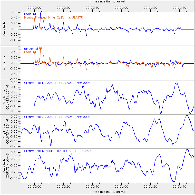
MPM Manuel Prospect Mine, California, USA - Earthquake Result Viewer
*The percent match for this event was below the threshold and hence no stack was calculated.
| Earthquake location: |
Vanuatu Islands |
| Earthquake latitude/longitude: |
-14.9/168.1 |
| Earthquake time(UTC): |
2008/11/07 (312) 09:40:00 GMT |
| Earthquake Depth: |
10 km |
| Earthquake Magnitude: |
5.5 MB, 4.9 MS, 5.5 MW |
| Earthquake Catalog/Contributor: |
WHDF/NEIC |
|
| Network: |
CI Caltech Regional Seismic Network |
| Station: |
MPM Manuel Prospect Mine, California, USA |
| Lat/Lon: |
36.06 N/117.49 W |
| Elevation: |
185 m |
|
| Distance: |
86.5 deg |
| Az: |
51.431 deg |
| Baz: |
248.871 deg |
| Ray Param: |
$rayparam |
*The percent match for this event was below the threshold and hence was not used in the summary stack. |
|
| Radial Match: |
90.029396 % |
| Radial Bump: |
400 |
| Transverse Match: |
54.8584 % |
| Transverse Bump: |
400 |
| SOD ConfigId: |
2658 |
| Insert Time: |
2010-03-05 20:27:36.949 +0000 |
| GWidth: |
2.5 |
| Max Bumps: |
400 |
| Tol: |
0.001 |
|
Signal To Noise
| Channel | StoN | STA | LTA |
| CI:MPM: :BHZ:20081107T09:52:11.994009Z | 1.3124081 | 3.0762337E-7 | 2.3439613E-7 |
| CI:MPM: :BHN:20081107T09:52:11.994009Z | 1.1085585 | 2.175418E-7 | 1.9623843E-7 |
| CI:MPM: :BHE:20081107T09:52:11.994009Z | 2.6326077 | 3.1175327E-7 | 1.1841995E-7 |
| Arrivals |
| Ps | |
| PpPs | |
| PsPs/PpSs | |


