You are here: Home > Network List > CI - Caltech Regional Seismic Network Stations List
> Station MPM Manuel Prospect Mine, California, USA > Earthquake Result Viewer
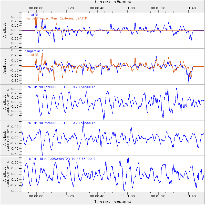
MPM Manuel Prospect Mine, California, USA - Earthquake Result Viewer
*The percent match for this event was below the threshold and hence no stack was calculated.
| Earthquake location: |
Santa Cruz Islands |
| Earthquake latitude/longitude: |
-11.8/166.5 |
| Earthquake time(UTC): |
2008/09/09 (253) 23:18:26 GMT |
| Earthquake Depth: |
99 km |
| Earthquake Magnitude: |
5.6 MW, 5.4 MB, 5.6 MW |
| Earthquake Catalog/Contributor: |
WHDF/NEIC |
|
| Network: |
CI Caltech Regional Seismic Network |
| Station: |
MPM Manuel Prospect Mine, California, USA |
| Lat/Lon: |
36.06 N/117.49 W |
| Elevation: |
185 m |
|
| Distance: |
85.8 deg |
| Az: |
52.03 deg |
| Baz: |
252.287 deg |
| Ray Param: |
$rayparam |
*The percent match for this event was below the threshold and hence was not used in the summary stack. |
|
| Radial Match: |
54.490433 % |
| Radial Bump: |
400 |
| Transverse Match: |
55.95952 % |
| Transverse Bump: |
400 |
| SOD ConfigId: |
2560 |
| Insert Time: |
2010-03-05 20:27:39.507 +0000 |
| GWidth: |
2.5 |
| Max Bumps: |
400 |
| Tol: |
0.001 |
|
Signal To Noise
| Channel | StoN | STA | LTA |
| CI:MPM: :BHZ:20080909T23:30:23.569001Z | 2.0102623 | 2.8520708E-7 | 1.4187556E-7 |
| CI:MPM: :BHN:20080909T23:30:23.569001Z | 0.75240695 | 1.09514026E-7 | 1.4555158E-7 |
| CI:MPM: :BHE:20080909T23:30:23.569001Z | 0.68076104 | 1.1152871E-7 | 1.6382945E-7 |
| Arrivals |
| Ps | |
| PpPs | |
| PsPs/PpSs | |


