You are here: Home > Network List > TA - USArray Transportable Network (new EarthScope stations) Stations List
> Station I23K Minto, Yukon-Koyukuk, AK, USA > Earthquake Result Viewer
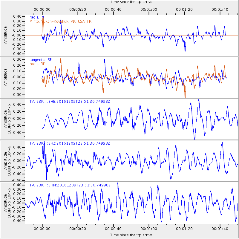
I23K Minto, Yukon-Koyukuk, AK, USA - Earthquake Result Viewer
*The percent match for this event was below the threshold and hence no stack was calculated.
| Earthquake location: |
Solomon Islands |
| Earthquake latitude/longitude: |
-10.4/161.3 |
| Earthquake time(UTC): |
2016/12/09 (344) 23:39:45 GMT |
| Earthquake Depth: |
69 km |
| Earthquake Magnitude: |
5.6 mb |
| Earthquake Catalog/Contributor: |
NEIC PDE/us |
|
| Network: |
TA USArray Transportable Network (new EarthScope stations) |
| Station: |
I23K Minto, Yukon-Koyukuk, AK, USA |
| Lat/Lon: |
65.15 N/149.36 W |
| Elevation: |
149 m |
|
| Distance: |
83.8 deg |
| Az: |
18.808 deg |
| Baz: |
228.632 deg |
| Ray Param: |
$rayparam |
*The percent match for this event was below the threshold and hence was not used in the summary stack. |
|
| Radial Match: |
56.000145 % |
| Radial Bump: |
400 |
| Transverse Match: |
42.62679 % |
| Transverse Bump: |
400 |
| SOD ConfigId: |
11737051 |
| Insert Time: |
2019-04-26 07:04:26.624 +0000 |
| GWidth: |
2.5 |
| Max Bumps: |
400 |
| Tol: |
0.001 |
|
Signal To Noise
| Channel | StoN | STA | LTA |
| TA:I23K: :BHZ:20161209T23:51:36.74998Z | 1.3124144 | 2.532212E-7 | 1.9294303E-7 |
| TA:I23K: :BHN:20161209T23:51:36.74998Z | 1.1940634 | 1.6064415E-7 | 1.3453568E-7 |
| TA:I23K: :BHE:20161209T23:51:36.74998Z | 1.2728081 | 1.7325479E-7 | 1.3612012E-7 |
| Arrivals |
| Ps | |
| PpPs | |
| PsPs/PpSs | |


