You are here: Home > Network List > CI - Caltech Regional Seismic Network Stations List
> Station MPM Manuel Prospect Mine, California, USA > Earthquake Result Viewer
MPM Manuel Prospect Mine, California, USA - Earthquake Result Viewer
*The percent match for this event was below the threshold and hence no stack was calculated.
| Earthquake location: |
Hokkaido, Japan Region |
| Earthquake latitude/longitude: |
41.5/139.0 |
| Earthquake time(UTC): |
2008/06/04 (156) 17:03:07 GMT |
| Earthquake Depth: |
213 km |
| Earthquake Magnitude: |
5.5 MB, 5.7 MW, 5.7 MW |
| Earthquake Catalog/Contributor: |
WHDF/NEIC |
|
| Network: |
CI Caltech Regional Seismic Network |
| Station: |
MPM Manuel Prospect Mine, California, USA |
| Lat/Lon: |
36.06 N/117.49 W |
| Elevation: |
185 m |
|
| Distance: |
75.8 deg |
| Az: |
54.38 deg |
| Baz: |
311.133 deg |
| Ray Param: |
$rayparam |
*The percent match for this event was below the threshold and hence was not used in the summary stack. |
|
| Radial Match: |
57.827877 % |
| Radial Bump: |
400 |
| Transverse Match: |
64.15713 % |
| Transverse Bump: |
400 |
| SOD ConfigId: |
2504 |
| Insert Time: |
2010-03-05 20:27:47.315 +0000 |
| GWidth: |
2.5 |
| Max Bumps: |
400 |
| Tol: |
0.001 |
|
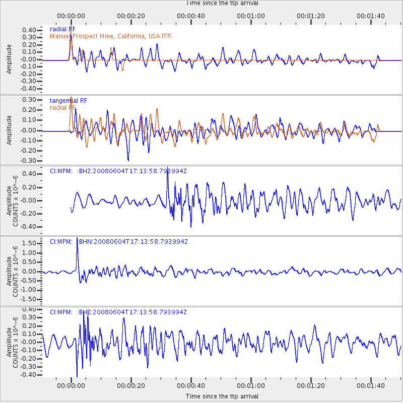
Signal To Noise
| Channel | StoN | STA | LTA |
| CI:MPM: :BHN:20080604T17:13:58.793994Z | 10.613587 | 4.7930405E-7 | 4.515947E-8 |
| CI:MPM: :BHE:20080604T17:13:58.793994Z | 1.9230132 | 1.4666266E-7 | 7.6267106E-8 |
| CI:MPM: :BHZ:20080604T17:13:58.793994Z | 2.6557937 | 1.5901648E-7 | 5.987531E-8 |
| Arrivals |
| Ps | |
| PpPs | |
| PsPs/PpSs | |


