You are here: Home > Network List > CI - Caltech Regional Seismic Network Stations List
> Station MPM Manuel Prospect Mine, California, USA > Earthquake Result Viewer
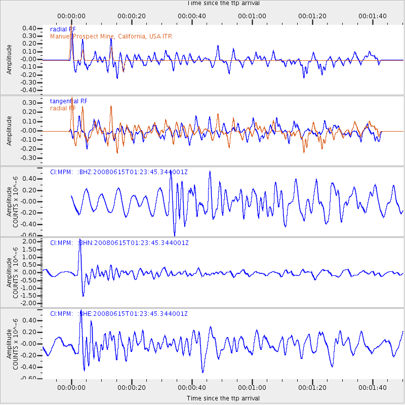
MPM Manuel Prospect Mine, California, USA - Earthquake Result Viewer
*The percent match for this event was below the threshold and hence no stack was calculated.
| Earthquake location: |
Fiji Islands Region |
| Earthquake latitude/longitude: |
-17.7/-179.7 |
| Earthquake time(UTC): |
2008/06/15 (167) 01:13:11 GMT |
| Earthquake Depth: |
611 km |
| Earthquake Magnitude: |
5.5 MB, 5.9 MW, 5.9 MW |
| Earthquake Catalog/Contributor: |
WHDF/NEIC |
|
| Network: |
CI Caltech Regional Seismic Network |
| Station: |
MPM Manuel Prospect Mine, California, USA |
| Lat/Lon: |
36.06 N/117.49 W |
| Elevation: |
185 m |
|
| Distance: |
79.5 deg |
| Az: |
46.826 deg |
| Baz: |
239.067 deg |
| Ray Param: |
$rayparam |
*The percent match for this event was below the threshold and hence was not used in the summary stack. |
|
| Radial Match: |
68.7188 % |
| Radial Bump: |
400 |
| Transverse Match: |
67.3402 % |
| Transverse Bump: |
316 |
| SOD ConfigId: |
2504 |
| Insert Time: |
2010-03-05 20:27:48.026 +0000 |
| GWidth: |
2.5 |
| Max Bumps: |
400 |
| Tol: |
0.001 |
|
Signal To Noise
| Channel | StoN | STA | LTA |
| CI:MPM: :BHN:20080615T01:23:45.344001Z | 5.2168283 | 8.535777E-7 | 1.6362006E-7 |
| CI:MPM: :BHE:20080615T01:23:45.344001Z | 1.7964835 | 2.3268832E-7 | 1.2952432E-7 |
| CI:MPM: :BHZ:20080615T01:23:45.344001Z | 2.1990323 | 2.9249514E-7 | 1.3301084E-7 |
| Arrivals |
| Ps | |
| PpPs | |
| PsPs/PpSs | |


