You are here: Home > Network List > CI - Caltech Regional Seismic Network Stations List
> Station MPM Manuel Prospect Mine, California, USA > Earthquake Result Viewer
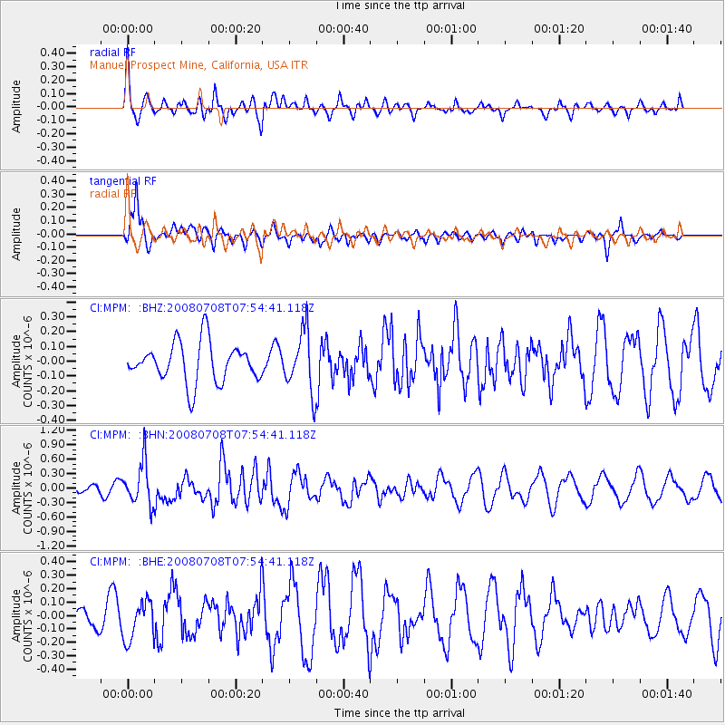
MPM Manuel Prospect Mine, California, USA - Earthquake Result Viewer
*The percent match for this event was below the threshold and hence no stack was calculated.
| Earthquake location: |
Ryukyu Islands, Japan |
| Earthquake latitude/longitude: |
27.5/128.3 |
| Earthquake time(UTC): |
2008/07/08 (190) 07:42:10 GMT |
| Earthquake Depth: |
43 km |
| Earthquake Magnitude: |
6.0 MB, 5.5 MS, 6.0 MW, 6.0 MW |
| Earthquake Catalog/Contributor: |
WHDF/NEIC |
|
| Network: |
CI Caltech Regional Seismic Network |
| Station: |
MPM Manuel Prospect Mine, California, USA |
| Lat/Lon: |
36.06 N/117.49 W |
| Elevation: |
185 m |
|
| Distance: |
91.4 deg |
| Az: |
47.685 deg |
| Baz: |
305.866 deg |
| Ray Param: |
$rayparam |
*The percent match for this event was below the threshold and hence was not used in the summary stack. |
|
| Radial Match: |
55.514313 % |
| Radial Bump: |
400 |
| Transverse Match: |
64.83753 % |
| Transverse Bump: |
355 |
| SOD ConfigId: |
2504 |
| Insert Time: |
2010-03-05 20:27:50.107 +0000 |
| GWidth: |
2.5 |
| Max Bumps: |
400 |
| Tol: |
0.001 |
|
Signal To Noise
| Channel | StoN | STA | LTA |
| CI:MPM: :BHN:20080708T07:54:41.118Z | 4.9139137 | 4.4529773E-7 | 9.061977E-8 |
| CI:MPM: :BHE:20080708T07:54:41.118Z | 0.78514534 | 1.4848408E-7 | 1.8911668E-7 |
| CI:MPM: :BHZ:20080708T07:54:41.118Z | 1.5441757 | 2.0646132E-7 | 1.3370325E-7 |
| Arrivals |
| Ps | |
| PpPs | |
| PsPs/PpSs | |


