You are here: Home > Network List > UW - Pacific Northwest Regional Seismic Network Stations List
> Station HOOD Mt Hood Meadows, OR CREST BB SMO > Earthquake Result Viewer
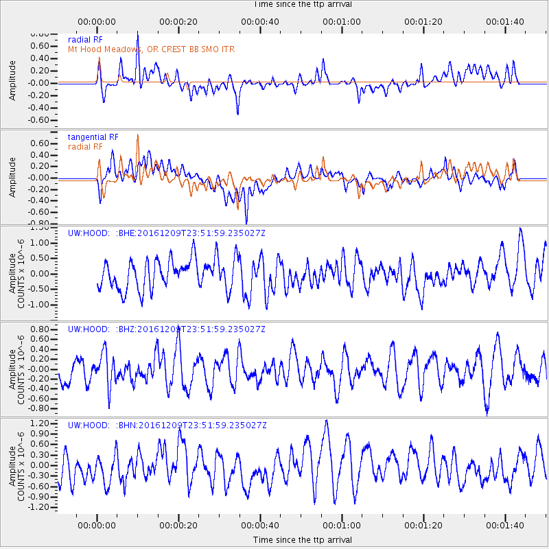
HOOD Mt Hood Meadows, OR CREST BB SMO - Earthquake Result Viewer
*The percent match for this event was below the threshold and hence no stack was calculated.
| Earthquake location: |
Solomon Islands |
| Earthquake latitude/longitude: |
-10.4/161.3 |
| Earthquake time(UTC): |
2016/12/09 (344) 23:39:45 GMT |
| Earthquake Depth: |
69 km |
| Earthquake Magnitude: |
5.6 mb |
| Earthquake Catalog/Contributor: |
NEIC PDE/us |
|
| Network: |
UW Pacific Northwest Regional Seismic Network |
| Station: |
HOOD Mt Hood Meadows, OR CREST BB SMO |
| Lat/Lon: |
45.32 N/121.65 W |
| Elevation: |
1520 m |
|
| Distance: |
88.4 deg |
| Az: |
43.455 deg |
| Baz: |
253.547 deg |
| Ray Param: |
$rayparam |
*The percent match for this event was below the threshold and hence was not used in the summary stack. |
|
| Radial Match: |
54.68647 % |
| Radial Bump: |
400 |
| Transverse Match: |
52.255184 % |
| Transverse Bump: |
400 |
| SOD ConfigId: |
11737051 |
| Insert Time: |
2019-04-26 07:05:11.619 +0000 |
| GWidth: |
2.5 |
| Max Bumps: |
400 |
| Tol: |
0.001 |
|
Signal To Noise
| Channel | StoN | STA | LTA |
| UW:HOOD: :BHZ:20161209T23:51:59.235027Z | 1.0767661 | 3.3474242E-7 | 3.1087754E-7 |
| UW:HOOD: :BHN:20161209T23:51:59.235027Z | 1.3559984 | 5.2965737E-7 | 3.9060325E-7 |
| UW:HOOD: :BHE:20161209T23:51:59.235027Z | 1.1839285 | 5.5294765E-7 | 4.6704477E-7 |
| Arrivals |
| Ps | |
| PpPs | |
| PsPs/PpSs | |


