You are here: Home > Network List > CI - Caltech Regional Seismic Network Stations List
> Station MPM Manuel Prospect Mine, California, USA > Earthquake Result Viewer
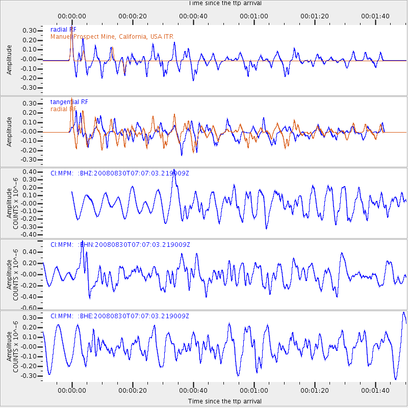
MPM Manuel Prospect Mine, California, USA - Earthquake Result Viewer
*The percent match for this event was below the threshold and hence no stack was calculated.
| Earthquake location: |
Eastern New Guinea Reg., P.N.G. |
| Earthquake latitude/longitude: |
-6.1/147.3 |
| Earthquake time(UTC): |
2008/08/30 (243) 06:54:07 GMT |
| Earthquake Depth: |
75 km |
| Earthquake Magnitude: |
6.1 MB, 6.4 MW, 6.3 MW |
| Earthquake Catalog/Contributor: |
WHDF/NEIC |
|
| Network: |
CI Caltech Regional Seismic Network |
| Station: |
MPM Manuel Prospect Mine, California, USA |
| Lat/Lon: |
36.06 N/117.49 W |
| Elevation: |
185 m |
|
| Distance: |
97.8 deg |
| Az: |
54.535 deg |
| Baz: |
268.101 deg |
| Ray Param: |
$rayparam |
*The percent match for this event was below the threshold and hence was not used in the summary stack. |
|
| Radial Match: |
59.344128 % |
| Radial Bump: |
393 |
| Transverse Match: |
69.98803 % |
| Transverse Bump: |
400 |
| SOD ConfigId: |
2504 |
| Insert Time: |
2010-03-05 20:27:52.339 +0000 |
| GWidth: |
2.5 |
| Max Bumps: |
400 |
| Tol: |
0.001 |
|
Signal To Noise
| Channel | StoN | STA | LTA |
| CI:MPM: :BHN:20080830T07:07:03.219009Z | 1.7131324 | 2.4992633E-7 | 1.458885E-7 |
| CI:MPM: :BHE:20080830T07:07:03.219009Z | 1.0811951 | 1.4878171E-7 | 1.3760857E-7 |
| CI:MPM: :BHZ:20080830T07:07:03.219009Z | 2.1897125 | 2.2676188E-7 | 1.0355784E-7 |
| Arrivals |
| Ps | |
| PpPs | |
| PsPs/PpSs | |


