You are here: Home > Network List > CI - Caltech Regional Seismic Network Stations List
> Station MPM Manuel Prospect Mine, California, USA > Earthquake Result Viewer
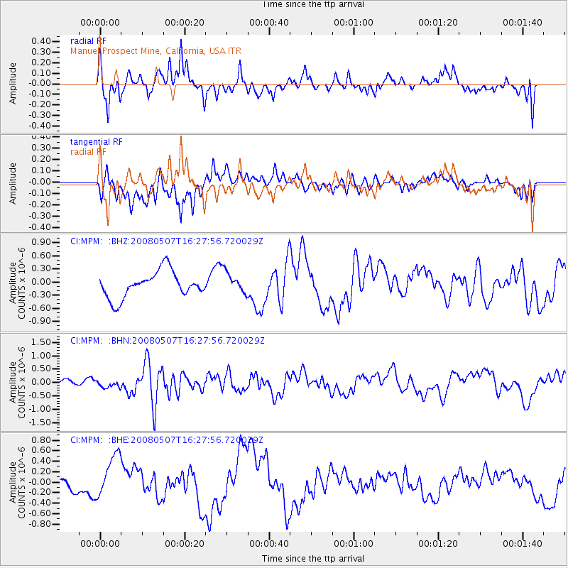
MPM Manuel Prospect Mine, California, USA - Earthquake Result Viewer
*The percent match for this event was below the threshold and hence no stack was calculated.
| Earthquake location: |
Near East Coast Of Honshu, Japan |
| Earthquake latitude/longitude: |
36.2/141.8 |
| Earthquake time(UTC): |
2008/05/07 (128) 16:16:36 GMT |
| Earthquake Depth: |
23 km |
| Earthquake Magnitude: |
5.9 MB, 6.1 MW, 6.0 MW |
| Earthquake Catalog/Contributor: |
WHDF/NEIC |
|
| Network: |
CI Caltech Regional Seismic Network |
| Station: |
MPM Manuel Prospect Mine, California, USA |
| Lat/Lon: |
36.06 N/117.49 W |
| Elevation: |
185 m |
|
| Distance: |
77.2 deg |
| Az: |
54.727 deg |
| Baz: |
305.373 deg |
| Ray Param: |
$rayparam |
*The percent match for this event was below the threshold and hence was not used in the summary stack. |
|
| Radial Match: |
58.28103 % |
| Radial Bump: |
400 |
| Transverse Match: |
34.53561 % |
| Transverse Bump: |
400 |
| SOD ConfigId: |
2504 |
| Insert Time: |
2010-03-05 20:27:58.789 +0000 |
| GWidth: |
2.5 |
| Max Bumps: |
400 |
| Tol: |
0.001 |
|
Signal To Noise
| Channel | StoN | STA | LTA |
| CI:MPM: :BHN:20080507T16:27:56.720029Z | 0.94094384 | 1.2851977E-7 | 1.3658602E-7 |
| CI:MPM: :BHE:20080507T16:27:56.720029Z | 2.0330737 | 4.1478052E-7 | 2.0401646E-7 |
| CI:MPM: :BHZ:20080507T16:27:56.720029Z | 0.7901347 | 2.3504936E-7 | 2.9748009E-7 |
| Arrivals |
| Ps | |
| PpPs | |
| PsPs/PpSs | |


