You are here: Home > Network List > AZ - ANZA Regional Network Stations List
> Station SMER AZ.SMER > Earthquake Result Viewer
SMER AZ.SMER - Earthquake Result Viewer
*The percent match for this event was below the threshold and hence no stack was calculated.
| Earthquake location: |
Solomon Islands |
| Earthquake latitude/longitude: |
-10.3/161.3 |
| Earthquake time(UTC): |
2016/12/10 (345) 02:38:21 GMT |
| Earthquake Depth: |
36 km |
| Earthquake Magnitude: |
5.6 Mwp |
| Earthquake Catalog/Contributor: |
NEIC PDE/us |
|
| Network: |
AZ ANZA Regional Network |
| Station: |
SMER AZ.SMER |
| Lat/Lon: |
33.46 N/117.17 W |
| Elevation: |
355 m |
|
| Distance: |
88.6 deg |
| Az: |
55.798 deg |
| Baz: |
256.778 deg |
| Ray Param: |
$rayparam |
*The percent match for this event was below the threshold and hence was not used in the summary stack. |
|
| Radial Match: |
75.96182 % |
| Radial Bump: |
400 |
| Transverse Match: |
62.53815 % |
| Transverse Bump: |
400 |
| SOD ConfigId: |
11737051 |
| Insert Time: |
2019-04-26 07:07:58.743 +0000 |
| GWidth: |
2.5 |
| Max Bumps: |
400 |
| Tol: |
0.001 |
|
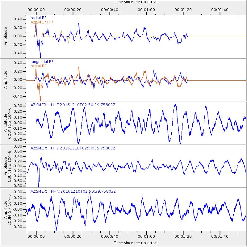
Signal To Noise
| Channel | StoN | STA | LTA |
| AZ:SMER: :HHZ:20161210T02:50:39.75803Z | 1.6729031 | 2.9483044E-7 | 1.7623881E-7 |
| AZ:SMER: :HHN:20161210T02:50:39.75803Z | 1.127655 | 1.01087366E-7 | 8.9643876E-8 |
| AZ:SMER: :HHE:20161210T02:50:39.75803Z | 0.5994295 | 9.03436E-8 | 1.5071596E-7 |
| Arrivals |
| Ps | |
| PpPs | |
| PsPs/PpSs | |


