You are here: Home > Network List > CI - Caltech Regional Seismic Network Stations List
> Station MPM Manuel Prospect Mine, California, USA > Earthquake Result Viewer
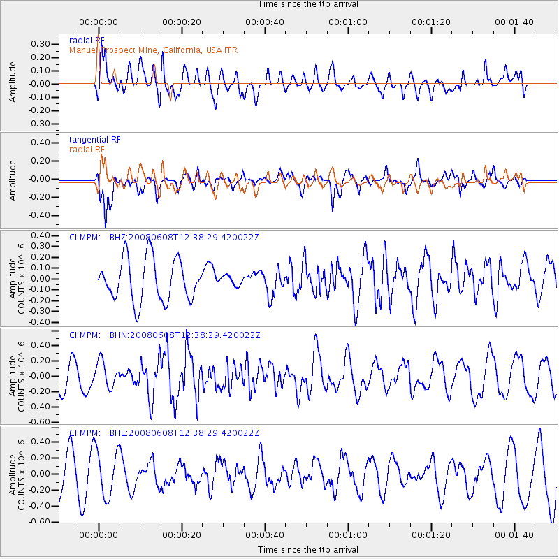
MPM Manuel Prospect Mine, California, USA - Earthquake Result Viewer
*The percent match for this event was below the threshold and hence no stack was calculated.
| Earthquake location: |
Southern Greece |
| Earthquake latitude/longitude: |
38.0/21.5 |
| Earthquake time(UTC): |
2008/06/08 (160) 12:25:29 GMT |
| Earthquake Depth: |
16 km |
| Earthquake Magnitude: |
6.2 MB, 6.3 MS, 6.3 MW, 6.3 MW |
| Earthquake Catalog/Contributor: |
WHDF/NEIC |
|
| Network: |
CI Caltech Regional Seismic Network |
| Station: |
MPM Manuel Prospect Mine, California, USA |
| Lat/Lon: |
36.06 N/117.49 W |
| Elevation: |
185 m |
|
| Distance: |
97.2 deg |
| Az: |
327.614 deg |
| Baz: |
31.498 deg |
| Ray Param: |
$rayparam |
*The percent match for this event was below the threshold and hence was not used in the summary stack. |
|
| Radial Match: |
64.730316 % |
| Radial Bump: |
400 |
| Transverse Match: |
67.636925 % |
| Transverse Bump: |
400 |
| SOD ConfigId: |
2504 |
| Insert Time: |
2010-03-05 20:28:02.512 +0000 |
| GWidth: |
2.5 |
| Max Bumps: |
400 |
| Tol: |
0.001 |
|
Signal To Noise
| Channel | StoN | STA | LTA |
| CI:MPM: :BHN:20080608T12:38:29.420022Z | 1.1643959 | 1.6998733E-7 | 1.4598758E-7 |
| CI:MPM: :BHE:20080608T12:38:29.420022Z | 1.6024281 | 2.8804365E-7 | 1.797545E-7 |
| CI:MPM: :BHZ:20080608T12:38:29.420022Z | 0.22567108 | 4.3772413E-8 | 1.9396553E-7 |
| Arrivals |
| Ps | |
| PpPs | |
| PsPs/PpSs | |


