You are here: Home > Network List > CI - Caltech Regional Seismic Network Stations List
> Station MPM Manuel Prospect Mine, California, USA > Earthquake Result Viewer
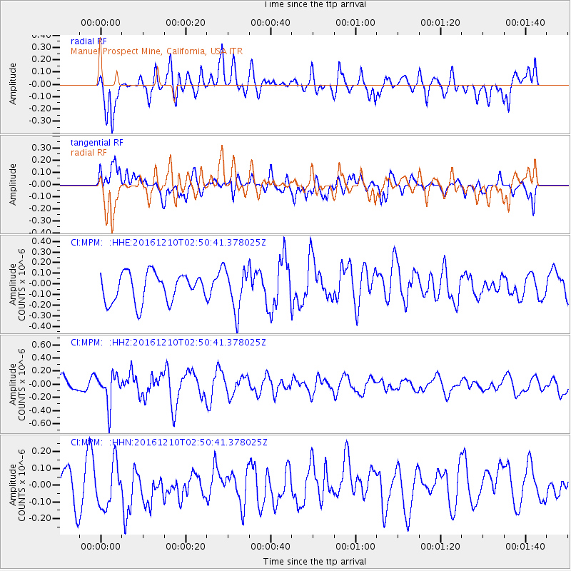
MPM Manuel Prospect Mine, California, USA - Earthquake Result Viewer
*The percent match for this event was below the threshold and hence no stack was calculated.
| Earthquake location: |
Solomon Islands |
| Earthquake latitude/longitude: |
-10.3/161.3 |
| Earthquake time(UTC): |
2016/12/10 (345) 02:38:21 GMT |
| Earthquake Depth: |
36 km |
| Earthquake Magnitude: |
5.6 Mwp |
| Earthquake Catalog/Contributor: |
NEIC PDE/us |
|
| Network: |
CI Caltech Regional Seismic Network |
| Station: |
MPM Manuel Prospect Mine, California, USA |
| Lat/Lon: |
36.06 N/117.49 W |
| Elevation: |
185 m |
|
| Distance: |
89.0 deg |
| Az: |
53.213 deg |
| Baz: |
256.544 deg |
| Ray Param: |
$rayparam |
*The percent match for this event was below the threshold and hence was not used in the summary stack. |
|
| Radial Match: |
67.85377 % |
| Radial Bump: |
400 |
| Transverse Match: |
39.435917 % |
| Transverse Bump: |
400 |
| SOD ConfigId: |
11737051 |
| Insert Time: |
2019-04-26 07:08:51.084 +0000 |
| GWidth: |
2.5 |
| Max Bumps: |
400 |
| Tol: |
0.001 |
|
Signal To Noise
| Channel | StoN | STA | LTA |
| CI:MPM: :HHZ:20161210T02:50:41.378025Z | 1.3242674 | 2.3264957E-7 | 1.7568172E-7 |
| CI:MPM: :HHN:20161210T02:50:41.378025Z | 1.3606535 | 1.4188267E-7 | 1.0427538E-7 |
| CI:MPM: :HHE:20161210T02:50:41.378025Z | 1.4628342 | 1.9586783E-7 | 1.3389612E-7 |
| Arrivals |
| Ps | |
| PpPs | |
| PsPs/PpSs | |


