You are here: Home > Network List > CI - Caltech Regional Seismic Network Stations List
> Station SDD Saddleback, Mission Viejo, CA, USA > Earthquake Result Viewer
SDD Saddleback, Mission Viejo, CA, USA - Earthquake Result Viewer
| Earthquake location: |
Near East Coast Of Honshu, Japan |
| Earthquake latitude/longitude: |
38.8/141.6 |
| Earthquake time(UTC): |
2003/05/26 (146) 09:24:33 GMT |
| Earthquake Depth: |
68 km |
| Earthquake Magnitude: |
6.7 MB, 7.0 MW, 7.0 MW |
| Earthquake Catalog/Contributor: |
WHDF/NEIC |
|
| Network: |
CI Caltech Regional Seismic Network |
| Station: |
SDD Saddleback, Mission Viejo, CA, USA |
| Lat/Lon: |
33.55 N/117.66 W |
| Elevation: |
120 m |
|
| Distance: |
77.2 deg |
| Az: |
57.281 deg |
| Baz: |
308.122 deg |
| Ray Param: |
0.050353296 |
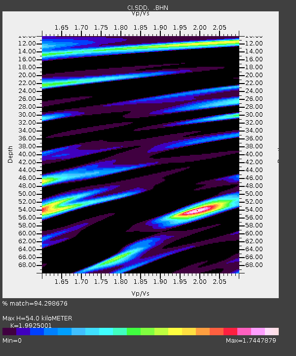
| Estimated Moho Depth: |
54.0 km |
| Estimated Crust Vp/Vs: |
1.99 |
| Assumed Crust Vp: |
6.264 km/s |
| Estimated Crust Vs: |
3.144 km/s |
| Estimated Crust Poisson's Ratio: |
0.33 |
|
| Radial Match: |
94.298676 % |
| Radial Bump: |
381 |
| Transverse Match: |
88.03008 % |
| Transverse Bump: |
400 |
| SOD ConfigId: |
3787 |
| Insert Time: |
2010-02-26 00:55:53.348 +0000 |
| GWidth: |
2.5 |
| Max Bumps: |
400 |
| Tol: |
0.001 |
|
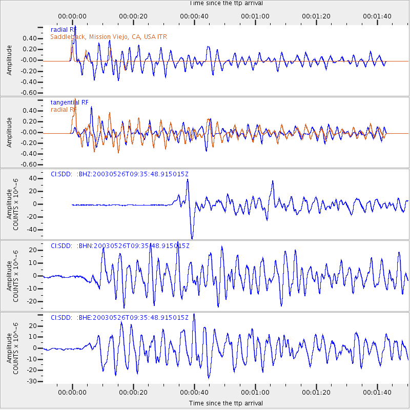
Signal To Noise
| Channel | StoN | STA | LTA |
| CI:SDD: :BHN:20030526T09:35:48.915015Z | 2.177921 | 1.0343207E-6 | 4.7491196E-7 |
| CI:SDD: :BHE:20030526T09:35:48.915015Z | 2.1916037 | 1.2028953E-6 | 5.4886533E-7 |
| CI:SDD: :BHZ:20030526T09:35:48.915015Z | 15.241708 | 4.797082E-6 | 3.1473388E-7 |
| Arrivals |
| Ps | 8.8 SECOND |
| PpPs | 25 SECOND |
| PsPs/PpSs | 34 SECOND |


