You are here: Home > Network List > CI - Caltech Regional Seismic Network Stations List
> Station MPM Manuel Prospect Mine, California, USA > Earthquake Result Viewer
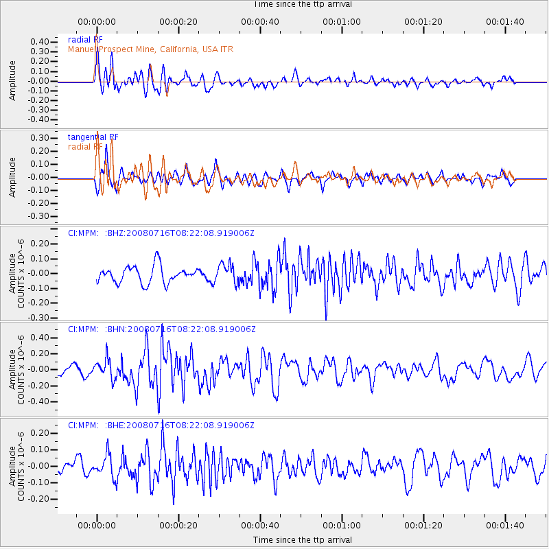
MPM Manuel Prospect Mine, California, USA - Earthquake Result Viewer
*The percent match for this event was below the threshold and hence no stack was calculated.
| Earthquake location: |
Samoa Islands Region |
| Earthquake latitude/longitude: |
-16.6/-173.0 |
| Earthquake time(UTC): |
2008/07/16 (198) 08:11:04 GMT |
| Earthquake Depth: |
10 km |
| Earthquake Magnitude: |
5.5 MB, 5.4 MS, 5.7 MW, 5.7 MW |
| Earthquake Catalog/Contributor: |
WHDF/NEIC |
|
| Network: |
CI Caltech Regional Seismic Network |
| Station: |
MPM Manuel Prospect Mine, California, USA |
| Lat/Lon: |
36.06 N/117.49 W |
| Elevation: |
185 m |
|
| Distance: |
74.1 deg |
| Az: |
43.959 deg |
| Baz: |
235.225 deg |
| Ray Param: |
$rayparam |
*The percent match for this event was below the threshold and hence was not used in the summary stack. |
|
| Radial Match: |
71.58186 % |
| Radial Bump: |
400 |
| Transverse Match: |
66.09568 % |
| Transverse Bump: |
400 |
| SOD ConfigId: |
2504 |
| Insert Time: |
2010-03-05 20:28:08.735 +0000 |
| GWidth: |
2.5 |
| Max Bumps: |
400 |
| Tol: |
0.001 |
|
Signal To Noise
| Channel | StoN | STA | LTA |
| CI:MPM: :BHN:20080716T08:22:08.919006Z | 1.9204446 | 1.2129689E-7 | 6.316083E-8 |
| CI:MPM: :BHE:20080716T08:22:08.919006Z | 1.833797 | 7.0159935E-8 | 3.825938E-8 |
| CI:MPM: :BHZ:20080716T08:22:08.919006Z | 1.1399517 | 6.3742206E-8 | 5.5916583E-8 |
| Arrivals |
| Ps | |
| PpPs | |
| PsPs/PpSs | |


