You are here: Home > Network List > CI - Caltech Regional Seismic Network Stations List
> Station SMM Simmler, CA, USA > Earthquake Result Viewer
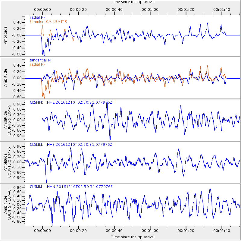
SMM Simmler, CA, USA - Earthquake Result Viewer
*The percent match for this event was below the threshold and hence no stack was calculated.
| Earthquake location: |
Solomon Islands |
| Earthquake latitude/longitude: |
-10.3/161.3 |
| Earthquake time(UTC): |
2016/12/10 (345) 02:38:21 GMT |
| Earthquake Depth: |
36 km |
| Earthquake Magnitude: |
5.6 Mwp |
| Earthquake Catalog/Contributor: |
NEIC PDE/us |
|
| Network: |
CI Caltech Regional Seismic Network |
| Station: |
SMM Simmler, CA, USA |
| Lat/Lon: |
35.31 N/120.00 W |
| Elevation: |
599 m |
|
| Distance: |
86.8 deg |
| Az: |
53.433 deg |
| Baz: |
255.096 deg |
| Ray Param: |
$rayparam |
*The percent match for this event was below the threshold and hence was not used in the summary stack. |
|
| Radial Match: |
54.359768 % |
| Radial Bump: |
400 |
| Transverse Match: |
55.021564 % |
| Transverse Bump: |
400 |
| SOD ConfigId: |
11737051 |
| Insert Time: |
2019-04-26 07:09:01.314 +0000 |
| GWidth: |
2.5 |
| Max Bumps: |
400 |
| Tol: |
0.001 |
|
Signal To Noise
| Channel | StoN | STA | LTA |
| CI:SMM: :HHZ:20161210T02:50:31.077976Z | 3.046317 | 4.533166E-7 | 1.4880808E-7 |
| CI:SMM: :HHN:20161210T02:50:31.077976Z | 0.66306096 | 1.6649153E-7 | 2.5109534E-7 |
| CI:SMM: :HHE:20161210T02:50:31.077976Z | 1.2789167 | 3.5306007E-7 | 2.760618E-7 |
| Arrivals |
| Ps | |
| PpPs | |
| PsPs/PpSs | |


