You are here: Home > Network List > CI - Caltech Regional Seismic Network Stations List
> Station MPM Manuel Prospect Mine, California, USA > Earthquake Result Viewer
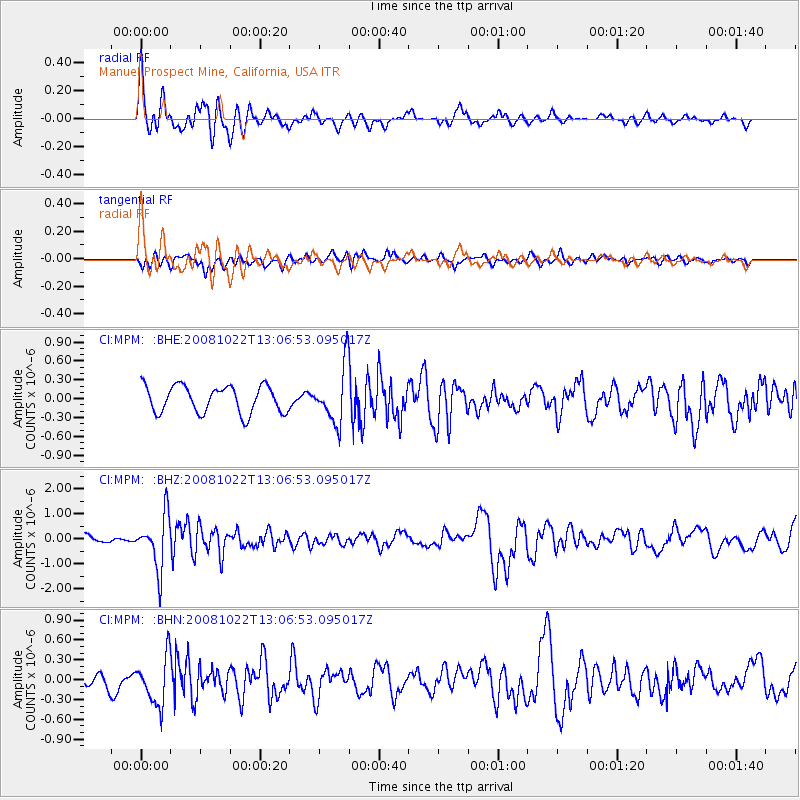
MPM Manuel Prospect Mine, California, USA - Earthquake Result Viewer
*The percent match for this event was below the threshold and hence no stack was calculated.
| Earthquake location: |
Tonga Islands |
| Earthquake latitude/longitude: |
-18.4/-175.4 |
| Earthquake time(UTC): |
2008/10/22 (296) 12:55:57 GMT |
| Earthquake Depth: |
233 km |
| Earthquake Magnitude: |
5.9 MB, 6.4 MW, 6.3 MW |
| Earthquake Catalog/Contributor: |
WHDF/NEIC |
|
| Network: |
CI Caltech Regional Seismic Network |
| Station: |
MPM Manuel Prospect Mine, California, USA |
| Lat/Lon: |
36.06 N/117.49 W |
| Elevation: |
185 m |
|
| Distance: |
77.0 deg |
| Az: |
44.768 deg |
| Baz: |
235.604 deg |
| Ray Param: |
$rayparam |
*The percent match for this event was below the threshold and hence was not used in the summary stack. |
|
| Radial Match: |
75.06674 % |
| Radial Bump: |
400 |
| Transverse Match: |
32.268723 % |
| Transverse Bump: |
386 |
| SOD ConfigId: |
2556 |
| Insert Time: |
2010-03-05 20:28:17.981 +0000 |
| GWidth: |
2.5 |
| Max Bumps: |
400 |
| Tol: |
0.001 |
|
Signal To Noise
| Channel | StoN | STA | LTA |
| CI:MPM: :BHZ:20081022T13:06:53.095017Z | 7.2988777 | 1.0511521E-6 | 1.4401559E-7 |
| CI:MPM: :BHN:20081022T13:06:53.095017Z | 3.227987 | 3.6213362E-7 | 1.1218559E-7 |
| CI:MPM: :BHE:20081022T13:06:53.095017Z | 2.0979722 | 4.5051607E-7 | 2.147388E-7 |
| Arrivals |
| Ps | |
| PpPs | |
| PsPs/PpSs | |


