You are here: Home > Network List > CI - Caltech Regional Seismic Network Stations List
> Station MPM Manuel Prospect Mine, California, USA > Earthquake Result Viewer
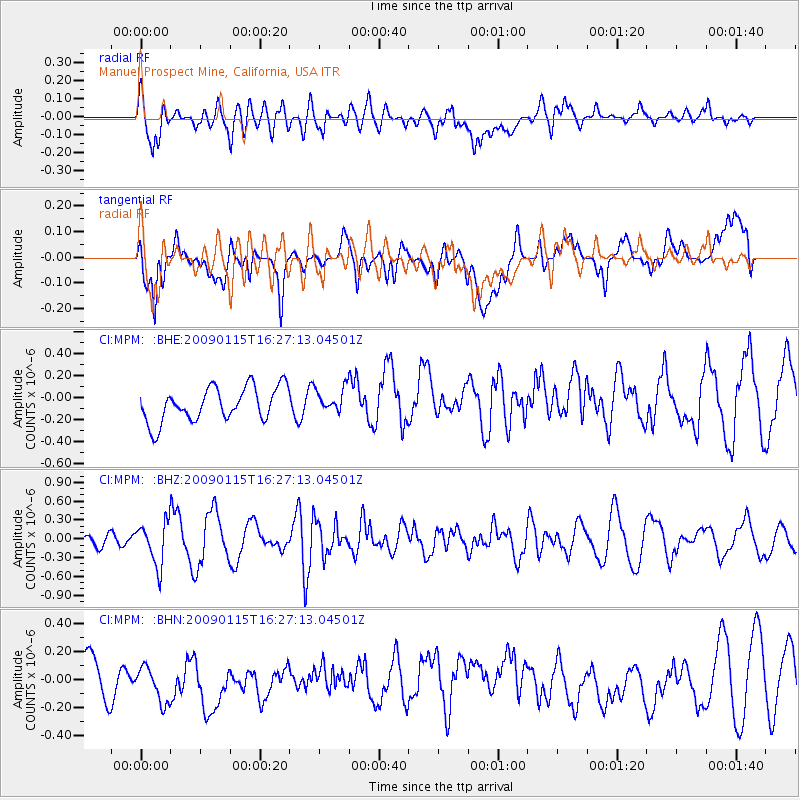
MPM Manuel Prospect Mine, California, USA - Earthquake Result Viewer
*The percent match for this event was below the threshold and hence no stack was calculated.
| Earthquake location: |
Solomon Islands |
| Earthquake latitude/longitude: |
-10.3/161.2 |
| Earthquake time(UTC): |
2009/01/15 (015) 16:15:01 GMT |
| Earthquake Depth: |
114 km |
| Earthquake Magnitude: |
5.6 MB, 5.7 MW, 5.7 MW |
| Earthquake Catalog/Contributor: |
WHDF/NEIC |
|
| Network: |
CI Caltech Regional Seismic Network |
| Station: |
MPM Manuel Prospect Mine, California, USA |
| Lat/Lon: |
36.06 N/117.49 W |
| Elevation: |
185 m |
|
| Distance: |
89.1 deg |
| Az: |
53.233 deg |
| Baz: |
256.605 deg |
| Ray Param: |
$rayparam |
*The percent match for this event was below the threshold and hence was not used in the summary stack. |
|
| Radial Match: |
62.227715 % |
| Radial Bump: |
400 |
| Transverse Match: |
63.872803 % |
| Transverse Bump: |
400 |
| SOD ConfigId: |
2834 |
| Insert Time: |
2010-03-05 20:28:29.811 +0000 |
| GWidth: |
2.5 |
| Max Bumps: |
400 |
| Tol: |
0.001 |
|
Signal To Noise
| Channel | StoN | STA | LTA |
| CI:MPM: :BHZ:20090115T16:27:13.04501Z | 2.953679 | 3.4238136E-7 | 1.1591691E-7 |
| CI:MPM: :BHN:20090115T16:27:13.04501Z | 1.021257 | 1.4739587E-7 | 1.4432787E-7 |
| CI:MPM: :BHE:20090115T16:27:13.04501Z | 0.729445 | 1.1345205E-7 | 1.5553202E-7 |
| Arrivals |
| Ps | |
| PpPs | |
| PsPs/PpSs | |


