You are here: Home > Network List > TA - USArray Transportable Network (new EarthScope stations) Stations List
> Station R32K Eaglecrest, AK, USA > Earthquake Result Viewer
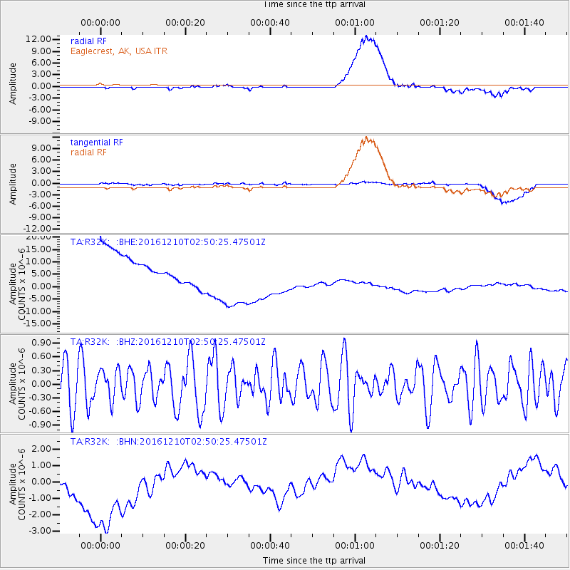
R32K Eaglecrest, AK, USA - Earthquake Result Viewer
*The percent match for this event was below the threshold and hence no stack was calculated.
| Earthquake location: |
Solomon Islands |
| Earthquake latitude/longitude: |
-10.3/161.3 |
| Earthquake time(UTC): |
2016/12/10 (345) 02:38:21 GMT |
| Earthquake Depth: |
36 km |
| Earthquake Magnitude: |
5.6 Mwp |
| Earthquake Catalog/Contributor: |
NEIC PDE/us |
|
| Network: |
TA USArray Transportable Network (new EarthScope stations) |
| Station: |
R32K Eaglecrest, AK, USA |
| Lat/Lon: |
58.27 N/134.52 W |
| Elevation: |
386 m |
|
| Distance: |
85.7 deg |
| Az: |
28.486 deg |
| Baz: |
242.643 deg |
| Ray Param: |
$rayparam |
*The percent match for this event was below the threshold and hence was not used in the summary stack. |
|
| Radial Match: |
20.05148 % |
| Radial Bump: |
400 |
| Transverse Match: |
18.870878 % |
| Transverse Bump: |
400 |
| SOD ConfigId: |
11737051 |
| Insert Time: |
2019-04-26 07:12:20.996 +0000 |
| GWidth: |
2.5 |
| Max Bumps: |
400 |
| Tol: |
0.001 |
|
Signal To Noise
| Channel | StoN | STA | LTA |
| TA:R32K: :BHZ:20161210T02:50:25.47501Z | 0.8143917 | 3.318706E-7 | 4.0750734E-7 |
| TA:R32K: :BHN:20161210T02:50:25.47501Z | 2.160607 | 3.693663E-6 | 1.7095488E-6 |
| TA:R32K: :BHE:20161210T02:50:25.47501Z | 2.4767277 | 1.438106E-5 | 5.8064757E-6 |
| Arrivals |
| Ps | |
| PpPs | |
| PsPs/PpSs | |


