You are here: Home > Network List > CI - Caltech Regional Seismic Network Stations List
> Station MPM Manuel Prospect Mine, California, USA > Earthquake Result Viewer
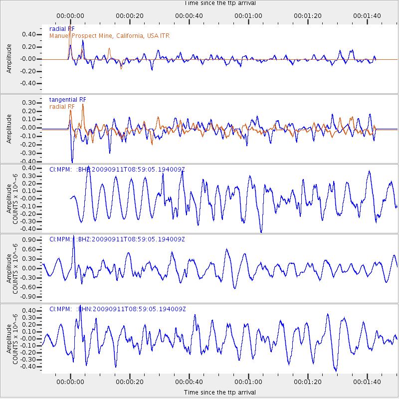
MPM Manuel Prospect Mine, California, USA - Earthquake Result Viewer
*The percent match for this event was below the threshold and hence no stack was calculated.
| Earthquake location: |
Kuril Islands |
| Earthquake latitude/longitude: |
48.3/154.2 |
| Earthquake time(UTC): |
2009/09/11 (254) 08:49:11 GMT |
| Earthquake Depth: |
35 km |
| Earthquake Magnitude: |
5.8 MB, 5.0 MS, 5.6 MW, 5.6 MW |
| Earthquake Catalog/Contributor: |
WHDF/NEIC |
|
| Network: |
CI Caltech Regional Seismic Network |
| Station: |
MPM Manuel Prospect Mine, California, USA |
| Lat/Lon: |
36.06 N/117.49 W |
| Elevation: |
185 m |
|
| Distance: |
63.1 deg |
| Az: |
65.258 deg |
| Baz: |
311.541 deg |
| Ray Param: |
$rayparam |
*The percent match for this event was below the threshold and hence was not used in the summary stack. |
|
| Radial Match: |
58.819427 % |
| Radial Bump: |
400 |
| Transverse Match: |
55.796577 % |
| Transverse Bump: |
400 |
| SOD ConfigId: |
2622 |
| Insert Time: |
2010-03-05 20:28:39.407 +0000 |
| GWidth: |
2.5 |
| Max Bumps: |
400 |
| Tol: |
0.001 |
|
Signal To Noise
| Channel | StoN | STA | LTA |
| CI:MPM: :BHZ:20090911T08:59:05.194009Z | 2.562297 | 3.4438696E-7 | 1.3440555E-7 |
| CI:MPM: :BHN:20090911T08:59:05.194009Z | 2.1412518 | 2.2835223E-7 | 1.0664427E-7 |
| CI:MPM: :BHE:20090911T08:59:05.194009Z | 0.6627727 | 1.2917558E-7 | 1.9490177E-7 |
| Arrivals |
| Ps | |
| PpPs | |
| PsPs/PpSs | |


