You are here: Home > Network List > CI - Caltech Regional Seismic Network Stations List
> Station MPM Manuel Prospect Mine, California, USA > Earthquake Result Viewer
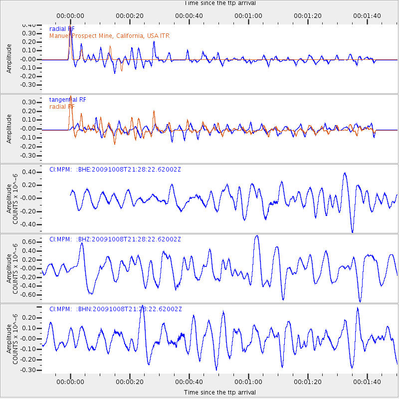
MPM Manuel Prospect Mine, California, USA - Earthquake Result Viewer
*The percent match for this event was below the threshold and hence no stack was calculated.
| Earthquake location: |
Santa Cruz Islands |
| Earthquake latitude/longitude: |
-12.9/166.3 |
| Earthquake time(UTC): |
2009/10/08 (281) 21:16:13 GMT |
| Earthquake Depth: |
35 km |
| Earthquake Magnitude: |
5.7 MB, 5.9 MS, 5.9 MW |
| Earthquake Catalog/Contributor: |
WHDF/NEIC |
|
| Network: |
CI Caltech Regional Seismic Network |
| Station: |
MPM Manuel Prospect Mine, California, USA |
| Lat/Lon: |
36.06 N/117.49 W |
| Elevation: |
185 m |
|
| Distance: |
86.7 deg |
| Az: |
52.021 deg |
| Baz: |
251.532 deg |
| Ray Param: |
$rayparam |
*The percent match for this event was below the threshold and hence was not used in the summary stack. |
|
| Radial Match: |
75.786934 % |
| Radial Bump: |
400 |
| Transverse Match: |
48.289944 % |
| Transverse Bump: |
400 |
| SOD ConfigId: |
2622 |
| Insert Time: |
2010-03-05 20:28:45.565 +0000 |
| GWidth: |
2.5 |
| Max Bumps: |
400 |
| Tol: |
0.001 |
|
Signal To Noise
| Channel | StoN | STA | LTA |
| CI:MPM: :BHZ:20091008T21:28:22.62002Z | 4.3292804 | 2.7708484E-7 | 6.400252E-8 |
| CI:MPM: :BHN:20091008T21:28:22.62002Z | 0.9066693 | 7.270695E-8 | 8.0191256E-8 |
| CI:MPM: :BHE:20091008T21:28:22.62002Z | 1.1522263 | 1.00142934E-7 | 8.691256E-8 |
| Arrivals |
| Ps | |
| PpPs | |
| PsPs/PpSs | |


