You are here: Home > Network List > CI - Caltech Regional Seismic Network Stations List
> Station MPM Manuel Prospect Mine, California, USA > Earthquake Result Viewer
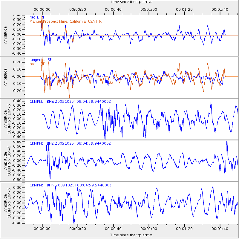
MPM Manuel Prospect Mine, California, USA - Earthquake Result Viewer
*The percent match for this event was below the threshold and hence no stack was calculated.
| Earthquake location: |
South Of Fiji Islands |
| Earthquake latitude/longitude: |
-23.1/-179.2 |
| Earthquake time(UTC): |
2009/10/25 (298) 07:53:52 GMT |
| Earthquake Depth: |
418 km |
| Earthquake Magnitude: |
5.6 MB, 6.0 MW, 5.9 MW |
| Earthquake Catalog/Contributor: |
WHDF/NEIC |
|
| Network: |
CI Caltech Regional Seismic Network |
| Station: |
MPM Manuel Prospect Mine, California, USA |
| Lat/Lon: |
36.06 N/117.49 W |
| Elevation: |
185 m |
|
| Distance: |
82.8 deg |
| Az: |
45.988 deg |
| Baz: |
234.816 deg |
| Ray Param: |
$rayparam |
*The percent match for this event was below the threshold and hence was not used in the summary stack. |
|
| Radial Match: |
65.82931 % |
| Radial Bump: |
400 |
| Transverse Match: |
33.763718 % |
| Transverse Bump: |
309 |
| SOD ConfigId: |
2622 |
| Insert Time: |
2010-03-05 20:28:50.093 +0000 |
| GWidth: |
2.5 |
| Max Bumps: |
400 |
| Tol: |
0.001 |
|
Signal To Noise
| Channel | StoN | STA | LTA |
| CI:MPM: :BHZ:20091025T08:04:59.944006Z | 3.2265885 | 3.3376494E-7 | 1.03442055E-7 |
| CI:MPM: :BHN:20091025T08:04:59.944006Z | 1.5592632 | 1.5686352E-7 | 1.00601056E-7 |
| CI:MPM: :BHE:20091025T08:04:59.944006Z | 0.9593627 | 1.5653897E-7 | 1.6316974E-7 |
| Arrivals |
| Ps | |
| PpPs | |
| PsPs/PpSs | |


