You are here: Home > Network List > CI - Caltech Regional Seismic Network Stations List
> Station MPM Manuel Prospect Mine, California, USA > Earthquake Result Viewer
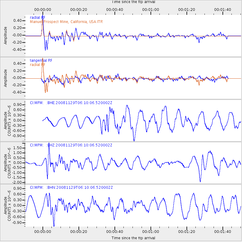
MPM Manuel Prospect Mine, California, USA - Earthquake Result Viewer
*The percent match for this event was below the threshold and hence no stack was calculated.
| Earthquake location: |
Fiji Islands Region |
| Earthquake latitude/longitude: |
-18.7/-177.7 |
| Earthquake time(UTC): |
2008/11/29 (334) 05:59:16 GMT |
| Earthquake Depth: |
386 km |
| Earthquake Magnitude: |
5.7 MB, 6.0 MW, 5.9 MW |
| Earthquake Catalog/Contributor: |
WHDF/NEIC |
|
| Network: |
CI Caltech Regional Seismic Network |
| Station: |
MPM Manuel Prospect Mine, California, USA |
| Lat/Lon: |
36.06 N/117.49 W |
| Elevation: |
185 m |
|
| Distance: |
78.8 deg |
| Az: |
45.811 deg |
| Baz: |
237.011 deg |
| Ray Param: |
$rayparam |
*The percent match for this event was below the threshold and hence was not used in the summary stack. |
|
| Radial Match: |
60.623863 % |
| Radial Bump: |
356 |
| Transverse Match: |
50.738594 % |
| Transverse Bump: |
367 |
| SOD ConfigId: |
2658 |
| Insert Time: |
2010-03-05 20:28:54.775 +0000 |
| GWidth: |
2.5 |
| Max Bumps: |
400 |
| Tol: |
0.001 |
|
Signal To Noise
| Channel | StoN | STA | LTA |
| CI:MPM: :BHZ:20081129T06:10:06.520002Z | 2.5310254 | 7.544008E-7 | 2.980613E-7 |
| CI:MPM: :BHN:20081129T06:10:06.520002Z | 1.553282 | 3.857106E-7 | 2.4831974E-7 |
| CI:MPM: :BHE:20081129T06:10:06.520002Z | 1.4371572 | 3.047541E-7 | 2.1205344E-7 |
| Arrivals |
| Ps | |
| PpPs | |
| PsPs/PpSs | |


