You are here: Home > Network List > CI - Caltech Regional Seismic Network Stations List
> Station MPM Manuel Prospect Mine, California, USA > Earthquake Result Viewer
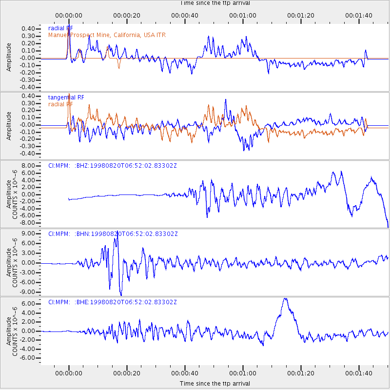
MPM Manuel Prospect Mine, California, USA - Earthquake Result Viewer
*The percent match for this event was below the threshold and hence no stack was calculated.
| Earthquake location: |
Bonin Islands, Japan Region |
| Earthquake latitude/longitude: |
28.9/139.3 |
| Earthquake time(UTC): |
1998/08/20 (232) 06:40:55 GMT |
| Earthquake Depth: |
441 km |
| Earthquake Magnitude: |
6.1 MB, 7.0 UNKNOWN, 7.0 MW |
| Earthquake Catalog/Contributor: |
WHDF/NEIC |
|
| Network: |
CI Caltech Regional Seismic Network |
| Station: |
MPM Manuel Prospect Mine, California, USA |
| Lat/Lon: |
36.06 N/117.49 W |
| Elevation: |
185 m |
|
| Distance: |
83.1 deg |
| Az: |
52.626 deg |
| Baz: |
300.719 deg |
| Ray Param: |
$rayparam |
*The percent match for this event was below the threshold and hence was not used in the summary stack. |
|
| Radial Match: |
42.84828 % |
| Radial Bump: |
400 |
| Transverse Match: |
49.489243 % |
| Transverse Bump: |
398 |
| SOD ConfigId: |
4480 |
| Insert Time: |
2010-03-05 20:28:55.416 +0000 |
| GWidth: |
2.5 |
| Max Bumps: |
400 |
| Tol: |
0.001 |
|
Signal To Noise
| Channel | StoN | STA | LTA |
| CI:MPM: :BHN:19980820T06:52:02.83302Z | 4.906546 | 2.8734695E-7 | 5.856399E-8 |
| CI:MPM: :BHE:19980820T06:52:02.83302Z | 1.0401745 | 2.0336475E-7 | 1.9551022E-7 |
| CI:MPM: :BHZ:19980820T06:52:02.83302Z | 0.9442664 | 4.1225402E-7 | 4.3658656E-7 |
| Arrivals |
| Ps | |
| PpPs | |
| PsPs/PpSs | |


