You are here: Home > Network List > CI - Caltech Regional Seismic Network Stations List
> Station MPM Manuel Prospect Mine, California, USA > Earthquake Result Viewer
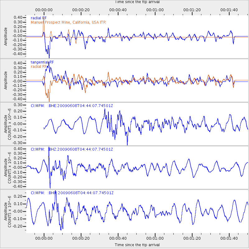
MPM Manuel Prospect Mine, California, USA - Earthquake Result Viewer
*The percent match for this event was below the threshold and hence no stack was calculated.
| Earthquake location: |
South Of Fiji Islands |
| Earthquake latitude/longitude: |
-22.2/-179.6 |
| Earthquake time(UTC): |
2009/06/08 (159) 04:33:19 GMT |
| Earthquake Depth: |
612 km |
| Earthquake Magnitude: |
5.5 MW, 5.2 MB |
| Earthquake Catalog/Contributor: |
WHDF/NEIC |
|
| Network: |
CI Caltech Regional Seismic Network |
| Station: |
MPM Manuel Prospect Mine, California, USA |
| Lat/Lon: |
36.06 N/117.49 W |
| Elevation: |
185 m |
|
| Distance: |
82.5 deg |
| Az: |
46.258 deg |
| Baz: |
235.699 deg |
| Ray Param: |
$rayparam |
*The percent match for this event was below the threshold and hence was not used in the summary stack. |
|
| Radial Match: |
60.395657 % |
| Radial Bump: |
400 |
| Transverse Match: |
49.87155 % |
| Transverse Bump: |
400 |
| SOD ConfigId: |
2648 |
| Insert Time: |
2010-03-05 20:29:00.139 +0000 |
| GWidth: |
2.5 |
| Max Bumps: |
400 |
| Tol: |
0.001 |
|
Signal To Noise
| Channel | StoN | STA | LTA |
| CI:MPM: :BHZ:20090608T04:44:07.74501Z | 3.0525472 | 1.7298126E-7 | 5.6667844E-8 |
| CI:MPM: :BHN:20090608T04:44:07.74501Z | 1.4957273 | 1.06768375E-7 | 7.1382246E-8 |
| CI:MPM: :BHE:20090608T04:44:07.74501Z | 1.6434633 | 1.1715713E-7 | 7.1286735E-8 |
| Arrivals |
| Ps | |
| PpPs | |
| PsPs/PpSs | |


