You are here: Home > Network List > TA - USArray Transportable Network (new EarthScope stations) Stations List
> Station G23K Bananza Creek, AK, USA > Earthquake Result Viewer
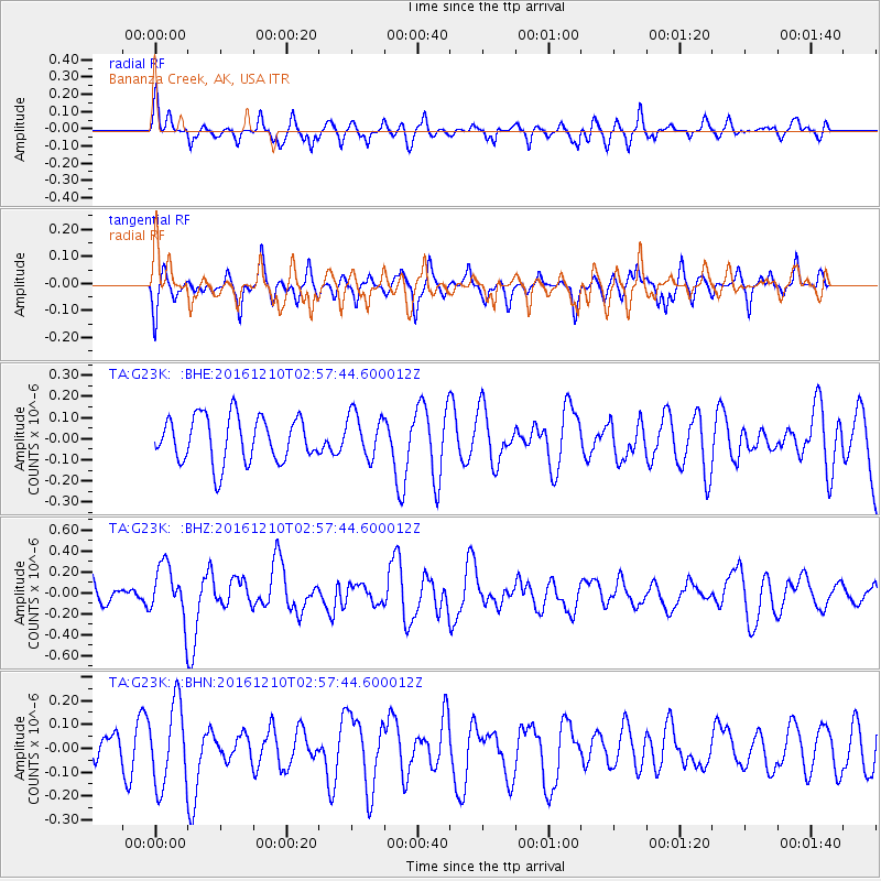
G23K Bananza Creek, AK, USA - Earthquake Result Viewer
*The percent match for this event was below the threshold and hence no stack was calculated.
| Earthquake location: |
Solomon Islands |
| Earthquake latitude/longitude: |
-10.9/161.3 |
| Earthquake time(UTC): |
2016/12/10 (345) 02:45:40 GMT |
| Earthquake Depth: |
10 km |
| Earthquake Magnitude: |
5.5 mb |
| Earthquake Catalog/Contributor: |
NEIC PDE/us |
|
| Network: |
TA USArray Transportable Network (new EarthScope stations) |
| Station: |
G23K Bananza Creek, AK, USA |
| Lat/Lon: |
66.71 N/150.02 W |
| Elevation: |
746 m |
|
| Distance: |
85.1 deg |
| Az: |
17.441 deg |
| Baz: |
227.767 deg |
| Ray Param: |
$rayparam |
*The percent match for this event was below the threshold and hence was not used in the summary stack. |
|
| Radial Match: |
63.03923 % |
| Radial Bump: |
362 |
| Transverse Match: |
24.63405 % |
| Transverse Bump: |
273 |
| SOD ConfigId: |
11737051 |
| Insert Time: |
2019-04-26 07:19:12.695 +0000 |
| GWidth: |
2.5 |
| Max Bumps: |
400 |
| Tol: |
0.001 |
|
Signal To Noise
| Channel | StoN | STA | LTA |
| TA:G23K: :BHZ:20161210T02:57:44.600012Z | 1.6891187 | 2.5290933E-7 | 1.4972856E-7 |
| TA:G23K: :BHN:20161210T02:57:44.600012Z | 1.8412884 | 1.7079893E-7 | 9.2760544E-8 |
| TA:G23K: :BHE:20161210T02:57:44.600012Z | 0.9786969 | 1.04712136E-7 | 1.06991386E-7 |
| Arrivals |
| Ps | |
| PpPs | |
| PsPs/PpSs | |


