You are here: Home > Network List > CI - Caltech Regional Seismic Network Stations List
> Station MPM Manuel Prospect Mine, California, USA > Earthquake Result Viewer
MPM Manuel Prospect Mine, California, USA - Earthquake Result Viewer
*The percent match for this event was below the threshold and hence no stack was calculated.
| Earthquake location: |
Vanuatu Islands |
| Earthquake latitude/longitude: |
-17.2/167.8 |
| Earthquake time(UTC): |
1998/09/30 (273) 03:03:56 GMT |
| Earthquake Depth: |
33 km |
| Earthquake Magnitude: |
5.5 MB, 5.6 MS, 5.8 UNKNOWN |
| Earthquake Catalog/Contributor: |
WHDF/NEIC |
|
| Network: |
CI Caltech Regional Seismic Network |
| Station: |
MPM Manuel Prospect Mine, California, USA |
| Lat/Lon: |
36.06 N/117.49 W |
| Elevation: |
185 m |
|
| Distance: |
88.1 deg |
| Az: |
51.436 deg |
| Baz: |
247.271 deg |
| Ray Param: |
$rayparam |
*The percent match for this event was below the threshold and hence was not used in the summary stack. |
|
| Radial Match: |
54.37017 % |
| Radial Bump: |
251 |
| Transverse Match: |
34.988007 % |
| Transverse Bump: |
390 |
| SOD ConfigId: |
4480 |
| Insert Time: |
2010-03-05 20:29:12.692 +0000 |
| GWidth: |
2.5 |
| Max Bumps: |
400 |
| Tol: |
0.001 |
|
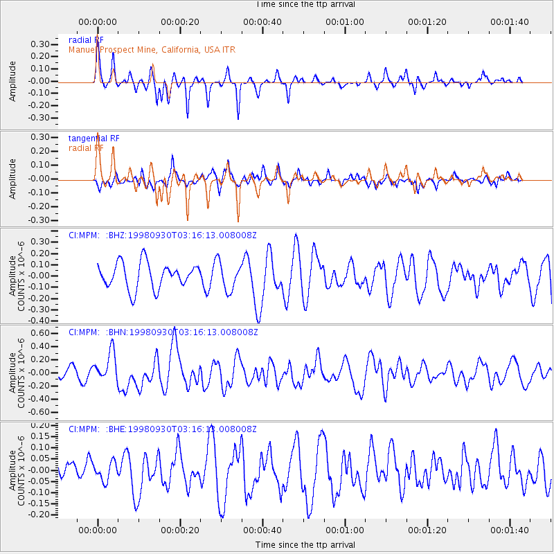
Signal To Noise
| Channel | StoN | STA | LTA |
| CI:MPM: :BHN:19980930T03:16:13.008008Z | 2.6806989 | 2.3415207E-7 | 8.7347395E-8 |
| CI:MPM: :BHE:19980930T03:16:13.008008Z | 0.6079934 | 4.1883688E-8 | 6.888839E-8 |
| CI:MPM: :BHZ:19980930T03:16:13.008008Z | 1.0955799 | 1.2358055E-7 | 1.1279921E-7 |
| Arrivals |
| Ps | |
| PpPs | |
| PsPs/PpSs | |


