You are here: Home > Network List > CI - Caltech Regional Seismic Network Stations List
> Station MPM Manuel Prospect Mine, California, USA > Earthquake Result Viewer
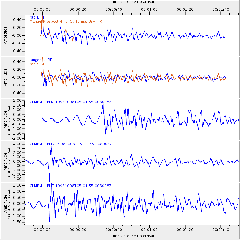
MPM Manuel Prospect Mine, California, USA - Earthquake Result Viewer
*The percent match for this event was below the threshold and hence no stack was calculated.
| Earthquake location: |
Southern Peru |
| Earthquake latitude/longitude: |
-16.1/-71.4 |
| Earthquake time(UTC): |
1998/10/08 (281) 04:51:42 GMT |
| Earthquake Depth: |
136 km |
| Earthquake Magnitude: |
6.1 MB, 6.4 UNKNOWN, 6.2 MW |
| Earthquake Catalog/Contributor: |
WHDF/NEIC |
|
| Network: |
CI Caltech Regional Seismic Network |
| Station: |
MPM Manuel Prospect Mine, California, USA |
| Lat/Lon: |
36.06 N/117.49 W |
| Elevation: |
185 m |
|
| Distance: |
67.8 deg |
| Az: |
320.903 deg |
| Baz: |
131.577 deg |
| Ray Param: |
$rayparam |
*The percent match for this event was below the threshold and hence was not used in the summary stack. |
|
| Radial Match: |
78.82084 % |
| Radial Bump: |
400 |
| Transverse Match: |
81.39572 % |
| Transverse Bump: |
400 |
| SOD ConfigId: |
4480 |
| Insert Time: |
2010-03-05 20:29:13.677 +0000 |
| GWidth: |
2.5 |
| Max Bumps: |
400 |
| Tol: |
0.001 |
|
Signal To Noise
| Channel | StoN | STA | LTA |
| CI:MPM: :BHN:19981008T05:01:55.008008Z | 4.1703067 | 1.4742322E-6 | 3.5350692E-7 |
| CI:MPM: :BHE:19981008T05:01:55.008008Z | 2.9973135 | 4.4255265E-7 | 1.4764977E-7 |
| CI:MPM: :BHZ:19981008T05:01:55.008008Z | 3.053671 | 7.465514E-7 | 2.444767E-7 |
| Arrivals |
| Ps | |
| PpPs | |
| PsPs/PpSs | |


