You are here: Home > Network List > CI - Caltech Regional Seismic Network Stations List
> Station MPM Manuel Prospect Mine, California, USA > Earthquake Result Viewer
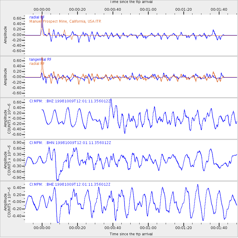
MPM Manuel Prospect Mine, California, USA - Earthquake Result Viewer
*The percent match for this event was below the threshold and hence no stack was calculated.
| Earthquake location: |
Near Coast Of Nicaragua |
| Earthquake latitude/longitude: |
11.3/-86.5 |
| Earthquake time(UTC): |
1998/10/09 (282) 11:54:36 GMT |
| Earthquake Depth: |
69 km |
| Earthquake Magnitude: |
5.5 MB, 5.7 MS, 6.0 UNKNOWN |
| Earthquake Catalog/Contributor: |
WHDF/NEIC |
|
| Network: |
CI Caltech Regional Seismic Network |
| Station: |
MPM Manuel Prospect Mine, California, USA |
| Lat/Lon: |
36.06 N/117.49 W |
| Elevation: |
185 m |
|
| Distance: |
37.3 deg |
| Az: |
316.441 deg |
| Baz: |
123.477 deg |
| Ray Param: |
$rayparam |
*The percent match for this event was below the threshold and hence was not used in the summary stack. |
|
| Radial Match: |
70.24576 % |
| Radial Bump: |
400 |
| Transverse Match: |
76.68546 % |
| Transverse Bump: |
325 |
| SOD ConfigId: |
4480 |
| Insert Time: |
2010-03-05 20:29:16.952 +0000 |
| GWidth: |
2.5 |
| Max Bumps: |
400 |
| Tol: |
0.001 |
|
Signal To Noise
| Channel | StoN | STA | LTA |
| CI:MPM: :BHN:19981009T12:01:11.356012Z | 1.6282555 | 2.847186E-7 | 1.7486113E-7 |
| CI:MPM: :BHE:19981009T12:01:11.356012Z | 0.69507855 | 1.2608845E-7 | 1.8140173E-7 |
| CI:MPM: :BHZ:19981009T12:01:11.356012Z | 0.820002 | 1.8584647E-7 | 2.2664148E-7 |
| Arrivals |
| Ps | |
| PpPs | |
| PsPs/PpSs | |


