You are here: Home > Network List > CI - Caltech Regional Seismic Network Stations List
> Station MPM Manuel Prospect Mine, California, USA > Earthquake Result Viewer
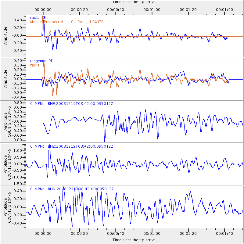
MPM Manuel Prospect Mine, California, USA - Earthquake Result Viewer
*The percent match for this event was below the threshold and hence no stack was calculated.
| Earthquake location: |
Northern Mid-Atlantic Ridge |
| Earthquake latitude/longitude: |
47.0/-27.3 |
| Earthquake time(UTC): |
2008/12/19 (354) 08:31:51 GMT |
| Earthquake Depth: |
2.0 km |
| Earthquake Magnitude: |
5.8 MB, 5.6 MS, 5.9 MW, 5.8 MW |
| Earthquake Catalog/Contributor: |
WHDF/NEIC |
|
| Network: |
CI Caltech Regional Seismic Network |
| Station: |
MPM Manuel Prospect Mine, California, USA |
| Lat/Lon: |
36.06 N/117.49 W |
| Elevation: |
185 m |
|
| Distance: |
64.8 deg |
| Az: |
296.452 deg |
| Baz: |
49.134 deg |
| Ray Param: |
$rayparam |
*The percent match for this event was below the threshold and hence was not used in the summary stack. |
|
| Radial Match: |
75.4801 % |
| Radial Bump: |
400 |
| Transverse Match: |
45.31764 % |
| Transverse Bump: |
400 |
| SOD ConfigId: |
2658 |
| Insert Time: |
2010-03-05 20:29:21.722 +0000 |
| GWidth: |
2.5 |
| Max Bumps: |
400 |
| Tol: |
0.001 |
|
Signal To Noise
| Channel | StoN | STA | LTA |
| CI:MPM: :BHZ:20081219T08:42:00.095012Z | 4.8533354 | 6.007839E-7 | 1.2378783E-7 |
| CI:MPM: :BHN:20081219T08:42:00.095012Z | 1.2682302 | 1.3961004E-7 | 1.1008256E-7 |
| CI:MPM: :BHE:20081219T08:42:00.095012Z | 1.680354 | 3.054205E-7 | 1.8175962E-7 |
| Arrivals |
| Ps | |
| PpPs | |
| PsPs/PpSs | |


