You are here: Home > Network List > AT - Alaska Tsunami Warning Seismic System Stations List
> Station TTA Tatalina, Alaska > Earthquake Result Viewer
TTA Tatalina, Alaska - Earthquake Result Viewer
| Earthquake location: |
Solomon Islands |
| Earthquake latitude/longitude: |
-5.7/154.5 |
| Earthquake time(UTC): |
2016/12/10 (345) 16:24:36 GMT |
| Earthquake Depth: |
157 km |
| Earthquake Magnitude: |
6.1 Mwp |
| Earthquake Catalog/Contributor: |
NEIC PDE/us |
|
| Network: |
AT Alaska Tsunami Warning Seismic System |
| Station: |
TTA Tatalina, Alaska |
| Lat/Lon: |
62.93 N/156.01 W |
| Elevation: |
990 m |
|
| Distance: |
78.0 deg |
| Az: |
20.837 deg |
| Baz: |
230.694 deg |
| Ray Param: |
0.04957938 |
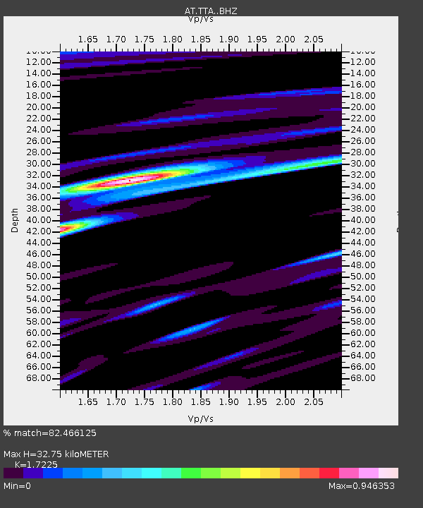
| Estimated Moho Depth: |
32.75 km |
| Estimated Crust Vp/Vs: |
1.72 |
| Assumed Crust Vp: |
6.182 km/s |
| Estimated Crust Vs: |
3.589 km/s |
| Estimated Crust Poisson's Ratio: |
0.25 |
|
| Radial Match: |
82.466125 % |
| Radial Bump: |
395 |
| Transverse Match: |
71.17602 % |
| Transverse Bump: |
400 |
| SOD ConfigId: |
11737051 |
| Insert Time: |
2019-04-26 07:23:36.061 +0000 |
| GWidth: |
2.5 |
| Max Bumps: |
400 |
| Tol: |
0.001 |
|

Signal To Noise
| Channel | StoN | STA | LTA |
| AT:TTA: :BHZ:20161210T16:35:46.29999Z | 6.0285873 | 1.3182869E-6 | 2.186726E-7 |
| AT:TTA: :BHN:20161210T16:35:46.29999Z | 2.5781069 | 5.121754E-7 | 1.9866336E-7 |
| AT:TTA: :BHE:20161210T16:35:46.29999Z | 2.2860942 | 2.7038473E-7 | 1.1827366E-7 |
| Arrivals |
| Ps | 3.9 SECOND |
| PpPs | 14 SECOND |
| PsPs/PpSs | 18 SECOND |


