You are here: Home > Network List > AV - Alaska Volcano Observatory Stations List
> Station MNAT Nateekin Bay, Makushin Volcano, Alaska > Earthquake Result Viewer
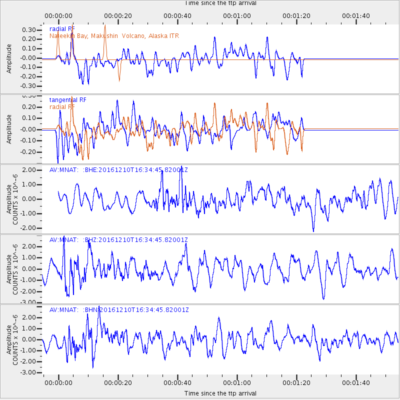
MNAT Nateekin Bay, Makushin Volcano, Alaska - Earthquake Result Viewer
*The percent match for this event was below the threshold and hence no stack was calculated.
| Earthquake location: |
Solomon Islands |
| Earthquake latitude/longitude: |
-5.7/154.5 |
| Earthquake time(UTC): |
2016/12/10 (345) 16:24:36 GMT |
| Earthquake Depth: |
157 km |
| Earthquake Magnitude: |
6.1 Mwp |
| Earthquake Catalog/Contributor: |
NEIC PDE/us |
|
| Network: |
AV Alaska Volcano Observatory |
| Station: |
MNAT Nateekin Bay, Makushin Volcano, Alaska |
| Lat/Lon: |
53.88 N/166.69 W |
| Elevation: |
390 m |
|
| Distance: |
67.7 deg |
| Az: |
23.658 deg |
| Baz: |
222.42 deg |
| Ray Param: |
$rayparam |
*The percent match for this event was below the threshold and hence was not used in the summary stack. |
|
| Radial Match: |
51.884857 % |
| Radial Bump: |
400 |
| Transverse Match: |
61.328773 % |
| Transverse Bump: |
400 |
| SOD ConfigId: |
11737051 |
| Insert Time: |
2019-04-26 07:24:03.984 +0000 |
| GWidth: |
2.5 |
| Max Bumps: |
400 |
| Tol: |
0.001 |
|
Signal To Noise
| Channel | StoN | STA | LTA |
| AV:MNAT: :BHZ:20161210T16:34:45.82001Z | 2.24629 | 1.3491821E-6 | 6.006269E-7 |
| AV:MNAT: :BHN:20161210T16:34:45.82001Z | 1.6290817 | 8.7985603E-7 | 5.4009325E-7 |
| AV:MNAT: :BHE:20161210T16:34:45.82001Z | 1.1642973 | 5.98543E-7 | 5.140809E-7 |
| Arrivals |
| Ps | |
| PpPs | |
| PsPs/PpSs | |


