You are here: Home > Network List > AV - Alaska Volcano Observatory Stations List
> Station SPCR Ckakachatna River, Mount Spurr, Alaska > Earthquake Result Viewer
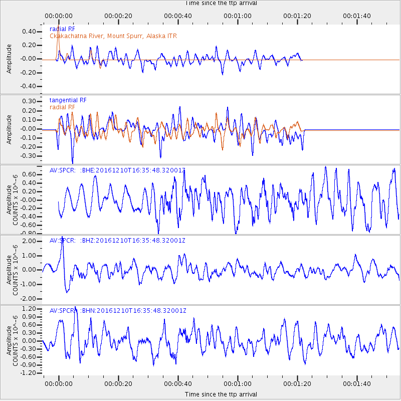
SPCR Ckakachatna River, Mount Spurr, Alaska - Earthquake Result Viewer
*The percent match for this event was below the threshold and hence no stack was calculated.
| Earthquake location: |
Solomon Islands |
| Earthquake latitude/longitude: |
-5.7/154.5 |
| Earthquake time(UTC): |
2016/12/10 (345) 16:24:36 GMT |
| Earthquake Depth: |
157 km |
| Earthquake Magnitude: |
6.1 Mwp |
| Earthquake Catalog/Contributor: |
NEIC PDE/us |
|
| Network: |
AV Alaska Volcano Observatory |
| Station: |
SPCR Ckakachatna River, Mount Spurr, Alaska |
| Lat/Lon: |
61.20 N/152.21 W |
| Elevation: |
984 m |
|
| Distance: |
78.3 deg |
| Az: |
23.357 deg |
| Baz: |
234.566 deg |
| Ray Param: |
$rayparam |
*The percent match for this event was below the threshold and hence was not used in the summary stack. |
|
| Radial Match: |
55.41285 % |
| Radial Bump: |
400 |
| Transverse Match: |
49.7548 % |
| Transverse Bump: |
400 |
| SOD ConfigId: |
11737051 |
| Insert Time: |
2019-04-26 07:24:13.836 +0000 |
| GWidth: |
2.5 |
| Max Bumps: |
400 |
| Tol: |
0.001 |
|
Signal To Noise
| Channel | StoN | STA | LTA |
| AV:SPCR: :BHZ:20161210T16:35:48.32001Z | 2.9267788 | 1.1019996E-6 | 3.7652305E-7 |
| AV:SPCR: :BHN:20161210T16:35:48.32001Z | 2.030442 | 5.528317E-7 | 2.7227162E-7 |
| AV:SPCR: :BHE:20161210T16:35:48.32001Z | 1.441387 | 3.4741E-7 | 2.4102476E-7 |
| Arrivals |
| Ps | |
| PpPs | |
| PsPs/PpSs | |


