You are here: Home > Network List > CI - Caltech Regional Seismic Network Stations List
> Station MPM Manuel Prospect Mine, California, USA > Earthquake Result Viewer
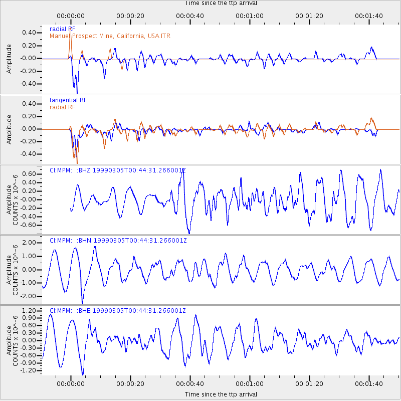
MPM Manuel Prospect Mine, California, USA - Earthquake Result Viewer
*The percent match for this event was below the threshold and hence no stack was calculated.
| Earthquake location: |
Chile-Bolivia Border Region |
| Earthquake latitude/longitude: |
-20.4/-68.9 |
| Earthquake time(UTC): |
1999/03/05 (064) 00:33:46 GMT |
| Earthquake Depth: |
111 km |
| Earthquake Magnitude: |
5.7 MB, 5.9 MW, 5.8 MW |
| Earthquake Catalog/Contributor: |
WHDF/NEIC |
|
| Network: |
CI Caltech Regional Seismic Network |
| Station: |
MPM Manuel Prospect Mine, California, USA |
| Lat/Lon: |
36.06 N/117.49 W |
| Elevation: |
185 m |
|
| Distance: |
72.6 deg |
| Az: |
320.437 deg |
| Baz: |
132.504 deg |
| Ray Param: |
$rayparam |
*The percent match for this event was below the threshold and hence was not used in the summary stack. |
|
| Radial Match: |
68.45314 % |
| Radial Bump: |
400 |
| Transverse Match: |
79.00482 % |
| Transverse Bump: |
400 |
| SOD ConfigId: |
4480 |
| Insert Time: |
2010-03-05 20:29:42.547 +0000 |
| GWidth: |
2.5 |
| Max Bumps: |
400 |
| Tol: |
0.001 |
|
Signal To Noise
| Channel | StoN | STA | LTA |
| CI:MPM: :BHN:19990305T00:44:31.266001Z | 1.8459212 | 1.3315586E-6 | 7.213518E-7 |
| CI:MPM: :BHE:19990305T00:44:31.266001Z | 1.2039053 | 7.6664156E-7 | 6.3679556E-7 |
| CI:MPM: :BHZ:19990305T00:44:31.266001Z | 0.46830744 | 9.067784E-8 | 1.9362886E-7 |
| Arrivals |
| Ps | |
| PpPs | |
| PsPs/PpSs | |


