You are here: Home > Network List > CI - Caltech Regional Seismic Network Stations List
> Station MPM Manuel Prospect Mine, California, USA > Earthquake Result Viewer
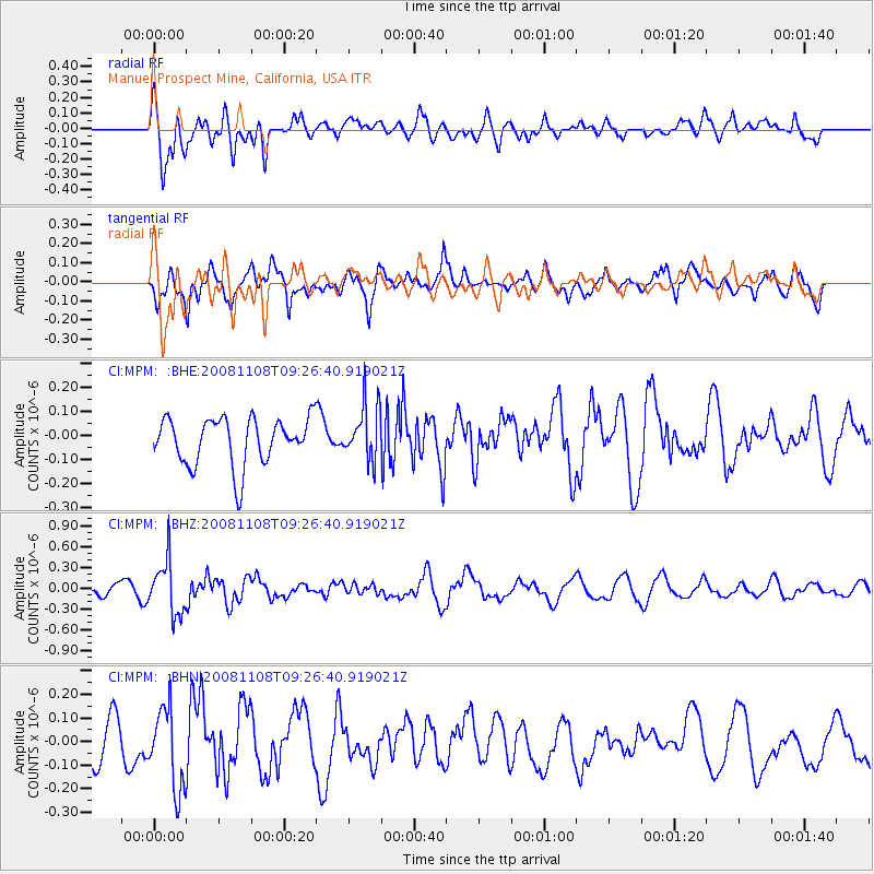
MPM Manuel Prospect Mine, California, USA - Earthquake Result Viewer
*The percent match for this event was below the threshold and hence no stack was calculated.
| Earthquake location: |
Tonga Islands |
| Earthquake latitude/longitude: |
-15.2/-174.2 |
| Earthquake time(UTC): |
2008/11/08 (313) 09:15:51 GMT |
| Earthquake Depth: |
140 km |
| Earthquake Magnitude: |
5.5 MW, 5.3 MB |
| Earthquake Catalog/Contributor: |
WHDF/NEIC |
|
| Network: |
CI Caltech Regional Seismic Network |
| Station: |
MPM Manuel Prospect Mine, California, USA |
| Lat/Lon: |
36.06 N/117.49 W |
| Elevation: |
185 m |
|
| Distance: |
74.0 deg |
| Az: |
44.819 deg |
| Baz: |
237.117 deg |
| Ray Param: |
$rayparam |
*The percent match for this event was below the threshold and hence was not used in the summary stack. |
|
| Radial Match: |
69.84021 % |
| Radial Bump: |
400 |
| Transverse Match: |
66.12236 % |
| Transverse Bump: |
400 |
| SOD ConfigId: |
2658 |
| Insert Time: |
2010-03-05 20:29:46.013 +0000 |
| GWidth: |
2.5 |
| Max Bumps: |
400 |
| Tol: |
0.001 |
|
Signal To Noise
| Channel | StoN | STA | LTA |
| CI:MPM: :BHZ:20081108T09:26:40.919021Z | 3.8754885 | 3.8933356E-7 | 1.0046051E-7 |
| CI:MPM: :BHN:20081108T09:26:40.919021Z | 1.8451992 | 1.7057614E-7 | 9.2443216E-8 |
| CI:MPM: :BHE:20081108T09:26:40.919021Z | 1.1689179 | 1.1526246E-7 | 9.860613E-8 |
| Arrivals |
| Ps | |
| PpPs | |
| PsPs/PpSs | |


