You are here: Home > Network List > CI - Caltech Regional Seismic Network Stations List
> Station SWS Sam W. Stewart, Westmorland, CA, USA > Earthquake Result Viewer
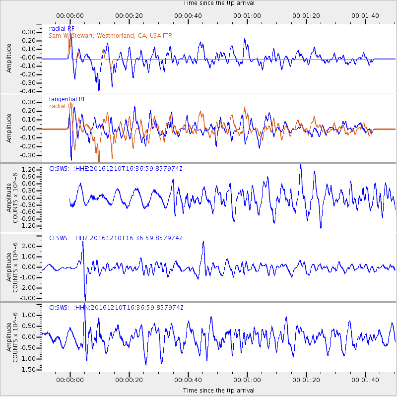
SWS Sam W. Stewart, Westmorland, CA, USA - Earthquake Result Viewer
*The percent match for this event was below the threshold and hence no stack was calculated.
| Earthquake location: |
Solomon Islands |
| Earthquake latitude/longitude: |
-5.7/154.5 |
| Earthquake time(UTC): |
2016/12/10 (345) 16:24:36 GMT |
| Earthquake Depth: |
157 km |
| Earthquake Magnitude: |
6.1 Mwp |
| Earthquake Catalog/Contributor: |
NEIC PDE/us |
|
| Network: |
CI Caltech Regional Seismic Network |
| Station: |
SWS Sam W. Stewart, Westmorland, CA, USA |
| Lat/Lon: |
32.94 N/115.80 W |
| Elevation: |
140 m |
|
| Distance: |
92.8 deg |
| Az: |
57.34 deg |
| Baz: |
265.115 deg |
| Ray Param: |
$rayparam |
*The percent match for this event was below the threshold and hence was not used in the summary stack. |
|
| Radial Match: |
75.97768 % |
| Radial Bump: |
400 |
| Transverse Match: |
62.30117 % |
| Transverse Bump: |
400 |
| SOD ConfigId: |
11737051 |
| Insert Time: |
2019-04-26 07:25:41.817 +0000 |
| GWidth: |
2.5 |
| Max Bumps: |
400 |
| Tol: |
0.001 |
|
Signal To Noise
| Channel | StoN | STA | LTA |
| CI:SWS: :HHZ:20161210T16:36:59.857974Z | 6.150296 | 8.0339754E-7 | 1.3062746E-7 |
| CI:SWS: :HHN:20161210T16:36:59.857974Z | 1.5833455 | 4.1450505E-7 | 2.6179066E-7 |
| CI:SWS: :HHE:20161210T16:36:59.857974Z | 1.2316604 | 3.0433992E-7 | 2.470973E-7 |
| Arrivals |
| Ps | |
| PpPs | |
| PsPs/PpSs | |


