You are here: Home > Network List > CI - Caltech Regional Seismic Network Stations List
> Station MPM Manuel Prospect Mine, California, USA > Earthquake Result Viewer
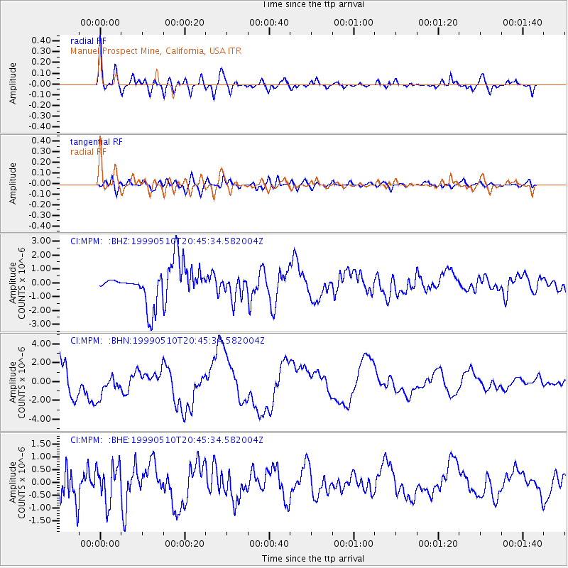
MPM Manuel Prospect Mine, California, USA - Earthquake Result Viewer
*The percent match for this event was below the threshold and hence no stack was calculated.
| Earthquake location: |
New Britain Region, P.N.G. |
| Earthquake latitude/longitude: |
-5.2/150.9 |
| Earthquake time(UTC): |
1999/05/10 (130) 20:33:02 GMT |
| Earthquake Depth: |
138 km |
| Earthquake Magnitude: |
6.5 MB, 6.8 MS, 7.1 MW, 6.5 MB |
| Earthquake Catalog/Contributor: |
WHDF/NEIC |
|
| Network: |
CI Caltech Regional Seismic Network |
| Station: |
MPM Manuel Prospect Mine, California, USA |
| Lat/Lon: |
36.06 N/117.49 W |
| Elevation: |
185 m |
|
| Distance: |
94.3 deg |
| Az: |
54.319 deg |
| Baz: |
266.794 deg |
| Ray Param: |
$rayparam |
*The percent match for this event was below the threshold and hence was not used in the summary stack. |
|
| Radial Match: |
77.944115 % |
| Radial Bump: |
400 |
| Transverse Match: |
80.30254 % |
| Transverse Bump: |
400 |
| SOD ConfigId: |
4480 |
| Insert Time: |
2010-03-05 20:30:07.457 +0000 |
| GWidth: |
2.5 |
| Max Bumps: |
400 |
| Tol: |
0.001 |
|
Signal To Noise
| Channel | StoN | STA | LTA |
| CI:MPM: :BHN:19990510T20:45:34.582004Z | 0.31177396 | 1.2308557E-6 | 3.9479105E-6 |
| CI:MPM: :BHE:19990510T20:45:34.582004Z | 1.5742335 | 7.252185E-7 | 4.6068038E-7 |
| CI:MPM: :BHZ:19990510T20:45:34.582004Z | 0.6858059 | 8.690581E-7 | 1.267207E-6 |
| Arrivals |
| Ps | |
| PpPs | |
| PsPs/PpSs | |


