You are here: Home > Network List > CI - Caltech Regional Seismic Network Stations List
> Station MPM Manuel Prospect Mine, California, USA > Earthquake Result Viewer
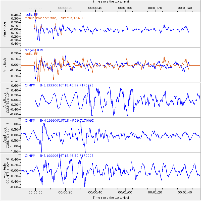
MPM Manuel Prospect Mine, California, USA - Earthquake Result Viewer
*The percent match for this event was below the threshold and hence no stack was calculated.
| Earthquake location: |
Tonga Islands |
| Earthquake latitude/longitude: |
-17.0/-173.4 |
| Earthquake time(UTC): |
1999/06/16 (167) 18:35:59 GMT |
| Earthquake Depth: |
75 km |
| Earthquake Magnitude: |
5.6 MB, 5.2 MS, 5.9 MW, 5.8 MW |
| Earthquake Catalog/Contributor: |
WHDF/NEIC |
|
| Network: |
CI Caltech Regional Seismic Network |
| Station: |
MPM Manuel Prospect Mine, California, USA |
| Lat/Lon: |
36.06 N/117.49 W |
| Elevation: |
185 m |
|
| Distance: |
74.7 deg |
| Az: |
44.066 deg |
| Baz: |
235.196 deg |
| Ray Param: |
$rayparam |
*The percent match for this event was below the threshold and hence was not used in the summary stack. |
|
| Radial Match: |
77.75005 % |
| Radial Bump: |
400 |
| Transverse Match: |
77.52284 % |
| Transverse Bump: |
400 |
| SOD ConfigId: |
4480 |
| Insert Time: |
2010-03-05 20:30:28.288 +0000 |
| GWidth: |
2.5 |
| Max Bumps: |
400 |
| Tol: |
0.001 |
|
Signal To Noise
| Channel | StoN | STA | LTA |
| CI:MPM: :BHN:19990616T18:46:59.717009Z | 2.8013067 | 5.8067525E-7 | 2.0728729E-7 |
| CI:MPM: :BHE:19990616T18:46:59.717009Z | 1.2678505 | 2.1418583E-7 | 1.6893618E-7 |
| CI:MPM: :BHZ:19990616T18:46:59.717009Z | 1.2657952 | 2.278753E-7 | 1.8002541E-7 |
| Arrivals |
| Ps | |
| PpPs | |
| PsPs/PpSs | |


