You are here: Home > Network List > CI - Caltech Regional Seismic Network Stations List
> Station MPM Manuel Prospect Mine, California, USA > Earthquake Result Viewer
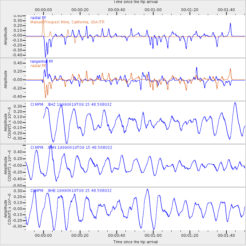
MPM Manuel Prospect Mine, California, USA - Earthquake Result Viewer
*The percent match for this event was below the threshold and hence no stack was calculated.
| Earthquake location: |
Eastern New Guinea Reg., P.N.G. |
| Earthquake latitude/longitude: |
-5.4/146.9 |
| Earthquake time(UTC): |
1999/06/19 (170) 09:03:09 GMT |
| Earthquake Depth: |
208 km |
| Earthquake Magnitude: |
5.7 MW, 5.1 MB, 5.6 MW |
| Earthquake Catalog/Contributor: |
WHDF/NEIC |
|
| Network: |
CI Caltech Regional Seismic Network |
| Station: |
MPM Manuel Prospect Mine, California, USA |
| Lat/Lon: |
36.06 N/117.49 W |
| Elevation: |
185 m |
|
| Distance: |
97.7 deg |
| Az: |
54.462 deg |
| Baz: |
268.919 deg |
| Ray Param: |
$rayparam |
*The percent match for this event was below the threshold and hence was not used in the summary stack. |
|
| Radial Match: |
49.058235 % |
| Radial Bump: |
400 |
| Transverse Match: |
83.941925 % |
| Transverse Bump: |
400 |
| SOD ConfigId: |
4480 |
| Insert Time: |
2010-03-05 20:30:29.822 +0000 |
| GWidth: |
2.5 |
| Max Bumps: |
400 |
| Tol: |
0.001 |
|
Signal To Noise
| Channel | StoN | STA | LTA |
| CI:MPM: :BHN:19990619T09:15:48.56803Z | 1.8545455 | 3.445674E-7 | 1.8579615E-7 |
| CI:MPM: :BHE:19990619T09:15:48.56803Z | 1.3951827 | 1.6255028E-7 | 1.1650825E-7 |
| CI:MPM: :BHZ:19990619T09:15:48.56803Z | 0.62882984 | 1.3075086E-7 | 2.0792727E-7 |
| Arrivals |
| Ps | |
| PpPs | |
| PsPs/PpSs | |


