You are here: Home > Network List > CI - Caltech Regional Seismic Network Stations List
> Station MPM Manuel Prospect Mine, California, USA > Earthquake Result Viewer
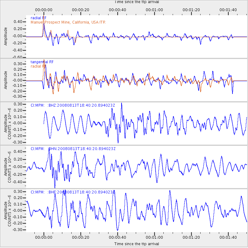
MPM Manuel Prospect Mine, California, USA - Earthquake Result Viewer
*The percent match for this event was below the threshold and hence no stack was calculated.
| Earthquake location: |
North Of Severnaya Zemlya |
| Earthquake latitude/longitude: |
83.6/114.5 |
| Earthquake time(UTC): |
2008/08/13 (226) 18:30:57 GMT |
| Earthquake Depth: |
10 km |
| Earthquake Magnitude: |
5.7 MW, 5.2 MS, 5.3 MB, 5.7 MW |
| Earthquake Catalog/Contributor: |
WHDF/NEIC |
|
| Network: |
CI Caltech Regional Seismic Network |
| Station: |
MPM Manuel Prospect Mine, California, USA |
| Lat/Lon: |
36.06 N/117.49 W |
| Elevation: |
185 m |
|
| Distance: |
58.3 deg |
| Az: |
48.655 deg |
| Baz: |
353.986 deg |
| Ray Param: |
$rayparam |
*The percent match for this event was below the threshold and hence was not used in the summary stack. |
|
| Radial Match: |
52.25071 % |
| Radial Bump: |
371 |
| Transverse Match: |
70.51654 % |
| Transverse Bump: |
400 |
| SOD ConfigId: |
2504 |
| Insert Time: |
2010-03-05 20:30:32.366 +0000 |
| GWidth: |
2.5 |
| Max Bumps: |
400 |
| Tol: |
0.001 |
|
Signal To Noise
| Channel | StoN | STA | LTA |
| CI:MPM: :BHN:20080813T18:40:20.894023Z | 1.8082627 | 2.1143843E-7 | 1.16929044E-7 |
| CI:MPM: :BHE:20080813T18:40:20.894023Z | 1.0165534 | 1.0559932E-7 | 1.0387975E-7 |
| CI:MPM: :BHZ:20080813T18:40:20.894023Z | 0.5268192 | 6.028065E-8 | 1.14423784E-7 |
| Arrivals |
| Ps | |
| PpPs | |
| PsPs/PpSs | |


