You are here: Home > Network List > TA - USArray Transportable Network (new EarthScope stations) Stations List
> Station F21K Alatna River, AK, USA > Earthquake Result Viewer
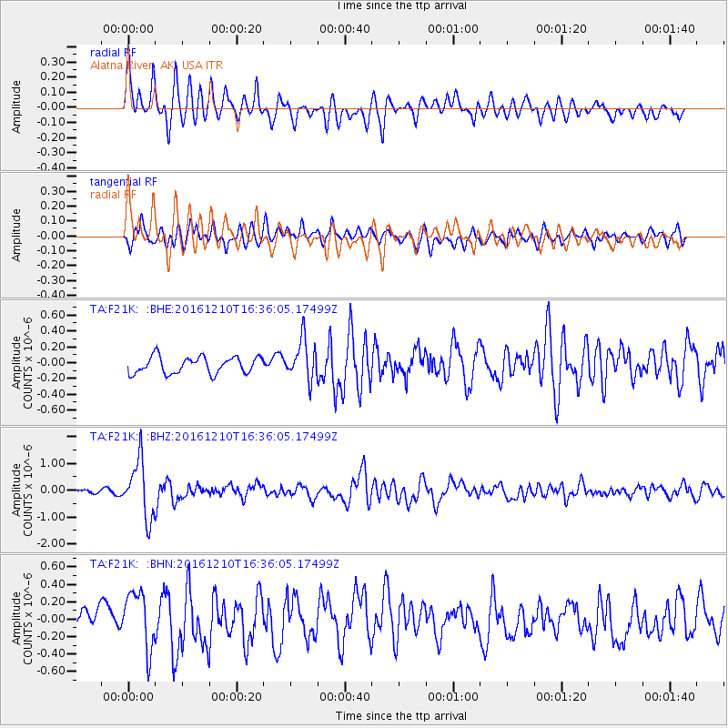
F21K Alatna River, AK, USA - Earthquake Result Viewer
*The percent match for this event was below the threshold and hence no stack was calculated.
| Earthquake location: |
Solomon Islands |
| Earthquake latitude/longitude: |
-5.7/154.5 |
| Earthquake time(UTC): |
2016/12/10 (345) 16:24:36 GMT |
| Earthquake Depth: |
157 km |
| Earthquake Magnitude: |
6.1 Mwp |
| Earthquake Catalog/Contributor: |
NEIC PDE/us |
|
| Network: |
TA USArray Transportable Network (new EarthScope stations) |
| Station: |
F21K Alatna River, AK, USA |
| Lat/Lon: |
67.22 N/153.48 W |
| Elevation: |
597 m |
|
| Distance: |
81.5 deg |
| Az: |
18.082 deg |
| Baz: |
232.494 deg |
| Ray Param: |
$rayparam |
*The percent match for this event was below the threshold and hence was not used in the summary stack. |
|
| Radial Match: |
74.88672 % |
| Radial Bump: |
400 |
| Transverse Match: |
57.184647 % |
| Transverse Bump: |
400 |
| SOD ConfigId: |
11737051 |
| Insert Time: |
2019-04-26 07:28:56.017 +0000 |
| GWidth: |
2.5 |
| Max Bumps: |
400 |
| Tol: |
0.001 |
|
Signal To Noise
| Channel | StoN | STA | LTA |
| TA:F21K: :BHZ:20161210T16:36:05.17499Z | 15.012169 | 1.086245E-6 | 7.235763E-8 |
| TA:F21K: :BHN:20161210T16:36:05.17499Z | 2.6442196 | 3.482253E-7 | 1.3169304E-7 |
| TA:F21K: :BHE:20161210T16:36:05.17499Z | 2.409244 | 2.5288614E-7 | 1.0496493E-7 |
| Arrivals |
| Ps | |
| PpPs | |
| PsPs/PpSs | |


