You are here: Home > Network List > CI - Caltech Regional Seismic Network Stations List
> Station MPM Manuel Prospect Mine, California, USA > Earthquake Result Viewer
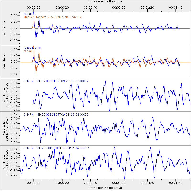
MPM Manuel Prospect Mine, California, USA - Earthquake Result Viewer
*The percent match for this event was below the threshold and hence no stack was calculated.
| Earthquake location: |
Kermadec Islands, New Zealand |
| Earthquake latitude/longitude: |
-29.9/-177.4 |
| Earthquake time(UTC): |
2008/11/06 (311) 09:11:05 GMT |
| Earthquake Depth: |
19 km |
| Earthquake Magnitude: |
5.6 MB, 5.7 MS, 5.9 MW, 5.9 MW |
| Earthquake Catalog/Contributor: |
WHDF/NEIC |
|
| Network: |
CI Caltech Regional Seismic Network |
| Station: |
MPM Manuel Prospect Mine, California, USA |
| Lat/Lon: |
36.06 N/117.49 W |
| Elevation: |
185 m |
|
| Distance: |
86.4 deg |
| Az: |
44.649 deg |
| Baz: |
228.889 deg |
| Ray Param: |
$rayparam |
*The percent match for this event was below the threshold and hence was not used in the summary stack. |
|
| Radial Match: |
63.059204 % |
| Radial Bump: |
400 |
| Transverse Match: |
43.76476 % |
| Transverse Bump: |
400 |
| SOD ConfigId: |
2658 |
| Insert Time: |
2010-03-05 20:30:37.645 +0000 |
| GWidth: |
2.5 |
| Max Bumps: |
400 |
| Tol: |
0.001 |
|
Signal To Noise
| Channel | StoN | STA | LTA |
| CI:MPM: :BHZ:20081106T09:23:15.620005Z | 1.4616854 | 2.1299904E-7 | 1.4572153E-7 |
| CI:MPM: :BHN:20081106T09:23:15.620005Z | 0.77224964 | 1.0270517E-7 | 1.3299478E-7 |
| CI:MPM: :BHE:20081106T09:23:15.620005Z | 1.4752725 | 1.6734022E-7 | 1.1343003E-7 |
| Arrivals |
| Ps | |
| PpPs | |
| PsPs/PpSs | |


