You are here: Home > Network List > CI - Caltech Regional Seismic Network Stations List
> Station MPM Manuel Prospect Mine, California, USA > Earthquake Result Viewer
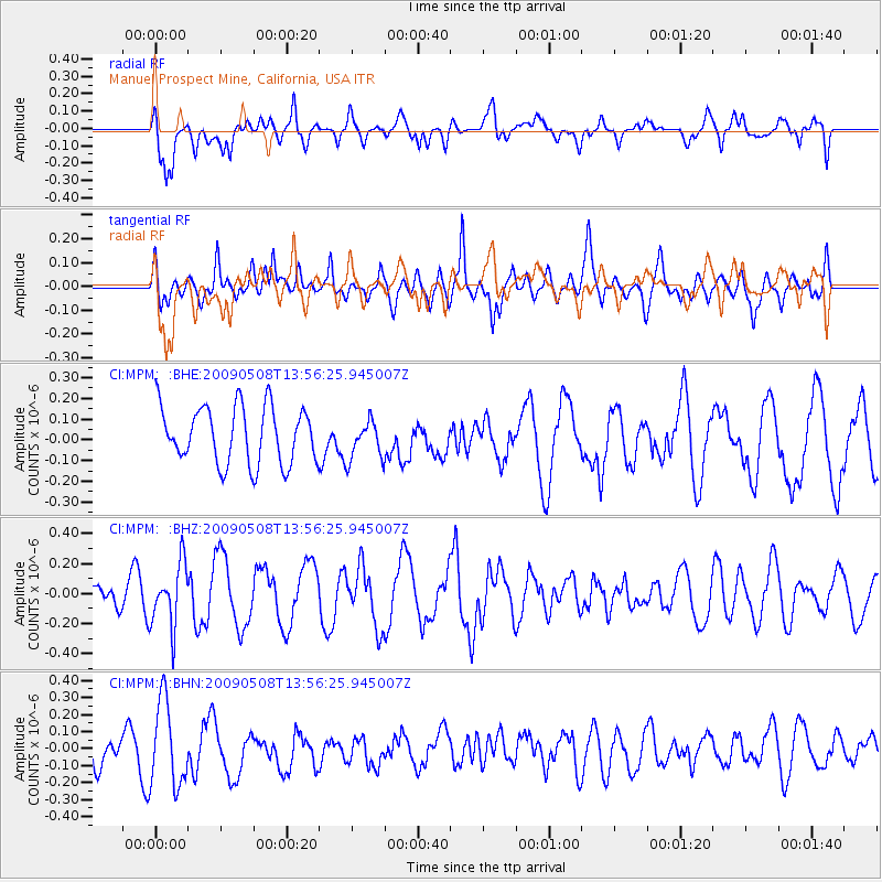
MPM Manuel Prospect Mine, California, USA - Earthquake Result Viewer
*The percent match for this event was below the threshold and hence no stack was calculated.
| Earthquake location: |
Mendoza Province, Argentina |
| Earthquake latitude/longitude: |
-32.1/-69.7 |
| Earthquake time(UTC): |
2009/05/08 (128) 13:44:53 GMT |
| Earthquake Depth: |
112 km |
| Earthquake Magnitude: |
5.6 MB, 5.4 MW |
| Earthquake Catalog/Contributor: |
WHDF/NEIC |
|
| Network: |
CI Caltech Regional Seismic Network |
| Station: |
MPM Manuel Prospect Mine, California, USA |
| Lat/Lon: |
36.06 N/117.49 W |
| Elevation: |
185 m |
|
| Distance: |
81.2 deg |
| Az: |
322.592 deg |
| Baz: |
140.462 deg |
| Ray Param: |
$rayparam |
*The percent match for this event was below the threshold and hence was not used in the summary stack. |
|
| Radial Match: |
60.815804 % |
| Radial Bump: |
400 |
| Transverse Match: |
51.04062 % |
| Transverse Bump: |
400 |
| SOD ConfigId: |
2658 |
| Insert Time: |
2010-03-05 20:30:38.986 +0000 |
| GWidth: |
2.5 |
| Max Bumps: |
400 |
| Tol: |
0.001 |
|
Signal To Noise
| Channel | StoN | STA | LTA |
| CI:MPM: :BHZ:20090508T13:56:25.945007Z | 4.1289697 | 2.0724816E-7 | 5.0193673E-8 |
| CI:MPM: :BHN:20090508T13:56:25.945007Z | 3.1117613 | 2.4831357E-7 | 7.979839E-8 |
| CI:MPM: :BHE:20090508T13:56:25.945007Z | 0.6925304 | 9.51561E-8 | 1.374035E-7 |
| Arrivals |
| Ps | |
| PpPs | |
| PsPs/PpSs | |


