You are here: Home > Network List > TA - USArray Transportable Network (new EarthScope stations) Stations List
> Station R17K Ugashik Creek, AK, USA > Earthquake Result Viewer
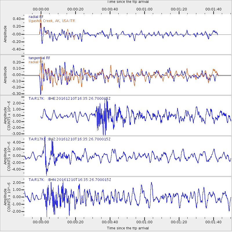
R17K Ugashik Creek, AK, USA - Earthquake Result Viewer
*The percent match for this event was below the threshold and hence no stack was calculated.
| Earthquake location: |
Solomon Islands |
| Earthquake latitude/longitude: |
-5.7/154.5 |
| Earthquake time(UTC): |
2016/12/10 (345) 16:24:36 GMT |
| Earthquake Depth: |
157 km |
| Earthquake Magnitude: |
6.1 Mwp |
| Earthquake Catalog/Contributor: |
NEIC PDE/us |
|
| Network: |
TA USArray Transportable Network (new EarthScope stations) |
| Station: |
R17K Ugashik Creek, AK, USA |
| Lat/Lon: |
57.64 N/156.39 W |
| Elevation: |
273 m |
|
| Distance: |
74.5 deg |
| Az: |
24.964 deg |
| Baz: |
231.352 deg |
| Ray Param: |
$rayparam |
*The percent match for this event was below the threshold and hence was not used in the summary stack. |
|
| Radial Match: |
67.97275 % |
| Radial Bump: |
400 |
| Transverse Match: |
67.322395 % |
| Transverse Bump: |
400 |
| SOD ConfigId: |
11737051 |
| Insert Time: |
2019-04-26 07:29:53.441 +0000 |
| GWidth: |
2.5 |
| Max Bumps: |
400 |
| Tol: |
0.001 |
|
Signal To Noise
| Channel | StoN | STA | LTA |
| TA:R17K: :BHZ:20161210T16:35:26.700015Z | 3.5753262 | 2.6691932E-6 | 7.465593E-7 |
| TA:R17K: :BHN:20161210T16:35:26.700015Z | 1.2322096 | 7.559404E-7 | 6.134837E-7 |
| TA:R17K: :BHE:20161210T16:35:26.700015Z | 2.067452 | 9.018573E-7 | 4.362168E-7 |
| Arrivals |
| Ps | |
| PpPs | |
| PsPs/PpSs | |


