You are here: Home > Network List > CI - Caltech Regional Seismic Network Stations List
> Station SCI2 SCI2, San Clemente Is. (NW tip), CA, USA > Earthquake Result Viewer
SCI2 SCI2, San Clemente Is. (NW tip), CA, USA - Earthquake Result Viewer
| Earthquake location: |
Near Coast Of Chiapas, Mexico |
| Earthquake latitude/longitude: |
14.4/-92.4 |
| Earthquake time(UTC): |
2008/10/16 (290) 19:41:25 GMT |
| Earthquake Depth: |
24 km |
| Earthquake Magnitude: |
6.1 MB, 6.6 MS, 6.7 MW, 6.6 MW |
| Earthquake Catalog/Contributor: |
WHDF/NEIC |
|
| Network: |
CI Caltech Regional Seismic Network |
| Station: |
SCI2 SCI2, San Clemente Is. (NW tip), CA, USA |
| Lat/Lon: |
32.98 N/118.55 W |
| Elevation: |
199 m |
|
| Distance: |
30.1 deg |
| Az: |
312.364 deg |
| Baz: |
121.601 deg |
| Ray Param: |
0.0793954 |
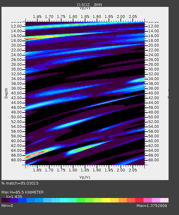
| Estimated Moho Depth: |
65.5 km |
| Estimated Crust Vp/Vs: |
1.63 |
| Assumed Crust Vp: |
6.048 km/s |
| Estimated Crust Vs: |
3.699 km/s |
| Estimated Crust Poisson's Ratio: |
0.20 |
|
| Radial Match: |
85.03015 % |
| Radial Bump: |
400 |
| Transverse Match: |
75.411804 % |
| Transverse Bump: |
400 |
| SOD ConfigId: |
2556 |
| Insert Time: |
2010-03-05 20:30:51.936 +0000 |
| GWidth: |
2.5 |
| Max Bumps: |
400 |
| Tol: |
0.001 |
|
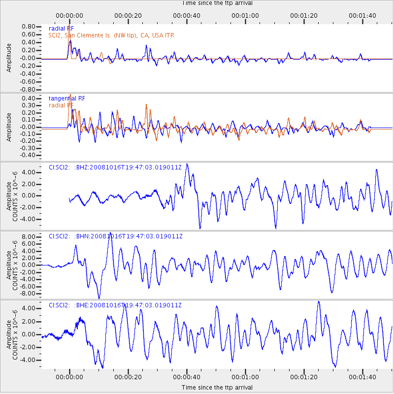
Signal To Noise
| Channel | StoN | STA | LTA |
| CI:SCI2: :BHN:20081016T19:47:03.019011Z | 8.660007 | 2.278654E-6 | 2.631238E-7 |
| CI:SCI2: :BHE:20081016T19:47:03.019011Z | 3.6402223 | 1.5481922E-6 | 4.2530155E-7 |
| CI:SCI2: :BHZ:20081016T19:47:03.019011Z | 1.6930965 | 9.843457E-7 | 5.8138784E-7 |
| Arrivals |
| Ps | 7.4 SECOND |
| PpPs | 26 SECOND |
| PsPs/PpSs | 34 SECOND |


